- Wound Up on Weather
- Posts
- 70s Next Wk & Probably Fat Tuesday
70s Next Wk & Probably Fat Tuesday
David Gilhousen
February 05, 2026

SUMMARY
Yahoo! After a few more below normal mornings, it’s time to sing “Tropical Heatwave” with Jack and Walter. We’ll be heading to above normal readings with afternoons at 70 or in the 70s for all of next week. After a brief cool down with highs in the 60s for next weekend, we’ll be probably get back into the 70 degree range for Fat Tuesday and Ash Wednesday.
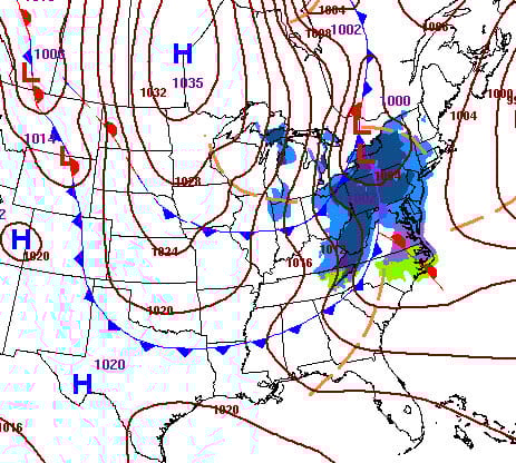
Let’s look for a reason, first for the cold start, by looking at the the surface map forecast for tomorrow. A low with snow in New York and a cold Canadian high in Manitoba will cause northerly winds and colder air for Saturday behind a cold front. However, the high is headed SE towards Ohio, not due south, and the systems are relatively far from us. So, we’re not talking about freezing weather.
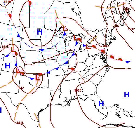
Then, by next Wednesday, the flow turns around to the south with some warm fronts (red half-circles) on the maps as well as cold fronts (blue triangles). Also, the Bermuda High starts poking in from the east evoking thoughts of summer. Of course, the surface systems are governed by features aloft which I’ve explained in earlier newsletters and are easier to forecast.
AT-A-GLANCE: SLIDELL
FORECAST DISCUSSION
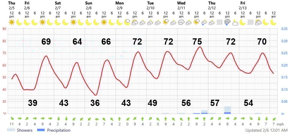
The Foreca graphic shows that after a cold start tomorrow, temperatures rapidly increase to a high of almost 70 in brilliant sunshine. The cold front doesn’t arrive until the wee hours of Saturday morning and it comes through with hardly a cloud. Saturday’s highs will be about five degrees lower and Sunday’s low will be about 36 at Slidell’s airport. So frost is possible in many suburban and rural areas of the Northshore, but not in the more protected areas.
Then, the warm up begins for the rest of week. But it won’t hit 70 everywhere….Next week’s highs will struggle to hit 70 near the Lake and Sound, but will be a few degrees warmer than shown in inland areas (Baton Rouge, Folsom, etc). AM Fog could be a concern for next Thursday and Friday. Note that most of the week will be dry except for a small chance of a piddly shower on Wednesday or Thursday evening. In fact, we’ll be lucky to get more than a quarter inch of rain in the next two weeks.
LONG-RANGE RAMBLINGS
For the next five days beyond the graph…
Saturday Feb 14 Low 49 High 65
Sunday Feb 15 Low 50 Highs 67 Chance of showers
Monday Feb 16 Low 51 High 64 Chance of showers
Tuesday Feb 17 Low 57 High 73
Wednesday Feb 18 Low 60 High 74
Expect cooler than normal temperatures from about Feb 21 through the first few days of March. Though this might mean a frost, I doubt it will mean a freeze. However, it will put an end to 70 degree weather. Precipitation should increase during this period.
As we look towards summer and hurricane season (Geesh, Gilhousen, you had to mention that), I expect El Nino conditions. That’s the opposite of what he had last year and this winter. It acts to suppress tropical development. Let’s see how that works its way into tropical outlooks as we go through the spring. I wish it would work its way into my insurance bill.