- Wound Up on Weather
- Posts
- A few wintry days remain
A few wintry days remain
David Gilhousen
March 12, 2026

SUMMARY
That was quite a blow that went through last evening. Fortunately, very few houses sustained damage and almost all of them were in Tangipahoa and Washington Parishes. However, all of us received quite a shock when we went out the door this morning. Winter had returned.
Tomorrow will do its best Arizona imitation. After a morning low in the low 40s on the Northshore, highs should zoom up into the low 70s under brilliant sunshine. Now all we need are some red rocks and canyons.
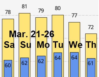
After a weekend, sunny warmup to the mid 70s on Saturday and the low 80s on Sunday, another “mother of all cold fronts” will speed through here with thunderstorms Sunday night. This ECMWF forecast for 1 AM Monday depicts the situation with a strong low over Michigan and a front at our doorstep. This front will NOT bring a tornado threat because the surface low and upper air support is far to the north. However, winds will gust like crazy with a front that is moving at 45 mph.
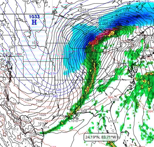
As you can tell with snow as far south as Missouri and all those packed, north-south black lines (isobars), it’s going to get cold and windy here for Monday where highs will be lucky to top the mid 50s. The real problem comes Tuesday morning with temperatures in the mid 30s. Will there be frost?
The answer depends on the position and shape of the high pressure area sliding south from North Dakota in the above graphic. On Tuesday morning, the ECMWF puts the high right over us and flattens it out causing the winds to go calm. That will give us widespread frost. The NWS believes (and I concur) that the center of the high will be further north as the GFS indicates. This would keep us windy without frost. Fingers crossed. Again, this would be a concern only for those in less developed, Northshore areas where your low temps. agree with Slidell’s airport.
AT-A-GLANCE: SLIDELL

FORECAST DISCUSSION
The Foreca graphic, which is based on the ECMWF and its kin, really drops the temperature and the winds Tuesday morning. They are forecasting about freezing temps! As mentioned earlier, I’m siding more with the NWS with my low of 36 and more wind at the Slidell airport. It’s just tough for the winds to go calm in a high pressure area this time of year in the Deep South.
The only rain chance is with the front Sunday night. A brief tenth of an inch or two seems reasonable given the speed of the front and the fact the Sunday won’t be as humid was it was yesterday. After the cold air passes…just beautiful sunny and spring-like weather for next Wednesday through Friday.
LONG-RANGE RAMBLINGS
Not much to say here. Nice early April-like weather for the six days beyond the Foreca graphic in late March. Next chance of rain is approximately Thursday March 26. Some models are forecasting another cold spell after that But in very late March, if that happens, we’re talking lows in the low 40s. Here’s the ECMWF forecast: