- Wound Up on Weather
- Posts
- Cloudy, cooler, humid weekend
Cloudy, cooler, humid weekend
David Gilhousen
September 30, 2025

SUMMARY
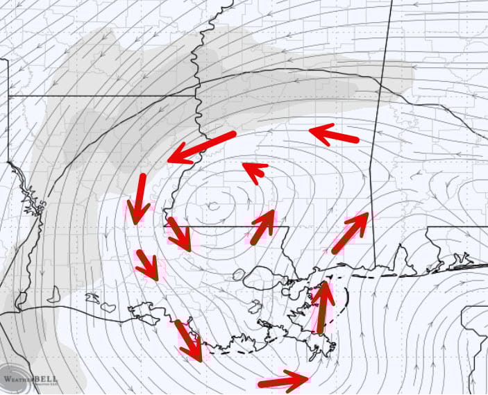
Yes, weather geeks are tripping out over the possibility of one hurricane gobbling up another’s remains. That’s very rare in the Atlantic. But back at the ranch, a change in the weather is headed our way. The Humberto-Imelda combo will be whipping moist Atlantic marine air westward across Florida and into the Gulf by Thursday. This will increase east-northeasterly winds, shown by the red arrows and showers over the Gulf, as shown by the green hatching in this German ICON forecast for late Thursday morning. Note that the showers are mostly offshore and also that it won’t be raining everywhere it’s green.
The next player in our weather will be a weak upper air low (or swirl) depicted by the arrows in this European model forecast of 18,000 ft winds for early Friday. To the right of the swirl the upper air winds are blowing from the south — this will bring in cloud tops from the offshore showers beginning late Friday and through the weekiend. Some of the showers should creep ashore late Saturday through early Monday as the swirl moves very slowly to the SW. The challenge will be the exact location of the low as models disagree and that will impact the timing and amount of rainfall
AT-A-GLANCE: SLIDELL
FORECAST DISCUSSION
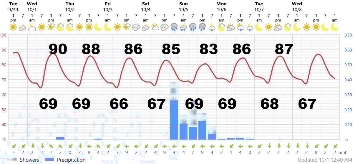
The Foreca graphic captures the essence of the forecast fairly welll. Tomorrow will be like today with the slightest chance of an afternoon sprinkle. Thursday will features a few more clouds and a 20% shower chance mostly Southshore and the I-10/12 corridor. Friday will see clouds increasing from the east which should hold high temperatures in the mid 80s. It could feel fairly pleasant with breezy east winds gusting into the 20 mph range, especially near the water. Lows will be near 70 in the humid air yet practically no chance of a shower.
Saturday will continue to be breezy and feature more clouds than sun with a chance of late afternoon or evening shower, If we were to get any significant rain — say a half-inch or more — late Saturday and Sunday would be the time. Highs could be limited to the low 80s Sunday. Showers should be breaking up & leaving a partly sunny and warmer Monday. Note that even with a return to sunny weather next week, highs stay in the upper 80s. Praise God for small victories.
LONG-RANGE RAMBLINGS
As we flip the calendar to October, I think I hear the faintest sounds of the Fat Lady singing backstage — that’s how Bob Breck describes his call of the end of hurricane season. However, the Fat Lady’s voice is about as rusty as LSU’s offense (and Penn State’s), so I’m giving her a week or two. Translation: I’m a bit concerned that a storm could develop near Jamaica in about two weeks and then head west towards Yucatan. Clearly, nothing is going to make it into the Caribbean from the Atlantic this year — we have to look closer to home. Models are showing weak wind shear in that area and some are trying to develop a depression or storm - but it’s too far out to really know.
The low level swirl presently in the South Central Gulf is heading to the Bay of Campeche, where even if it develops, it should go on into Mexico. Something weak might develop east of Florida late this weekend and head north, but I doubt it.
Still no clear indication of that first real Canadian cold front. It will be a warm and dry October. Accuweather, which attempts 3-4 week forecasts with some very modest skill, has backed off any cold front reaching us in the entire month of October!
ALABAMA & NW FL BEACHES

Foreca graphic for Pensacola Beach shows a similar pattern but with cooler high temperatues, stronger wind, and less rainfall. Strong winds from Thursday to Sunday will kick up the surf -- so its strictly shopping and pool weather.