- Wound Up on Weather
- Posts
- Cold Week Ahead with Hard Freeze
Cold Week Ahead with Hard Freeze
David Gilhousen
January 22, 2026

SUMMARY
Unlike many places in the Upper South, we’re in no danger of freezing rain this weekend. However, after the cold air arrives on Sunday, we’re in for seven days of low temperatures in the 20s and 30s. Tuesday morning could plummet into the upper teens in many rural areas. First, I’ll explain the reasons using maps, then I’ll show the at-a-glance forecast, and venture out onto thin ice with the long-range.
So why the cold? This is the ECMWF model forecast of upper air conditions Sunday over our part of the Northern Hemisphere. The red and purple areas show temperatures warmer than normal and the blue areas below normal. Notice that the cold air has been displaced southward from the North Pole, this causes the cold air to spill into Southern Canada, the U.S, and Europe. The warm air over Alaska and Greenland serves as a block. Wait a second. Could this be Greenland’s revenge on us, especially since Washington is going to shut down, buried in snow?

East of that cold trough over west Texas, a low pressure area is going to form just offshore from Lousiaina as shown by this NWS forecast map for Saturday night. That low will head northeast along the orange dashed line towards Birmingham and Chattanooga. Eventually, another low will form off the Carolinas, take over, and head up the coast. The blue areas show snow, the orange mostly freezing rain, and the greens are rain. Note that the freezing rain is well away from us in Dallas, Shreveport, Monroe, and Tennessee. It’s simply not getting this far south ahead of the low. The cold air won’t arrive until after the low moves east of us on Sunday.

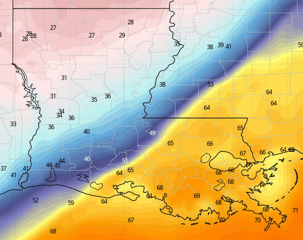
Looking at this on a smaller scale, let’s look at the ECMWF temperature forecast for 6 AM Sunday. You don’t need to be a weatherman to pick out the front. Look at the crazy almost 30 degree temperature difference between between McComb, MS and Natchez. This means that the orange trough line in the previous graphic may set up 70 miles further west and that Sunday will start warm before the front moves through mid-day.
AT-A-GLANCE: SLIDELL

FORECAST DISCUSSION
The Foreca graphic shows a thunderstorm Saturday night or Sunday morning ahead the front. Many could get an inch or more of rain. Temperatures will drop like a rock Sunday afternoon through Monday morning before bottoming out in the mid 20s. Even the Southshore could hit 30 with gusty conditions on the bridges.
Winds will die down on Monday under sunny skies with highs mid 40s before a night with a hard freeze. Morning lows upper teens to near 20 will be common in most rural and suburban areas except those in more developed areas which should stop closer to 25. Southshore again at or near freezing. Then, a slow recovery in temperatures through the week.
LONG-RANGE RAMBLINGS
This is a very challenging and uncertain forecast. I’m leaning in the direction of the American GFS which develops another low pressure area in the Gulf next Friday and Saturday. This could make for a very wet and cold last day of January. In fact, parts of the South such as Birmingham might get snow out of this. If this verifies, I hope they cancel Mardi Gras parades.
Saturday Jan. 31 Low 35 High 41 Occasional Rain
Sunday Feb. 1 Low 25 High 50