- Wound Up on Weather
- Posts
- Deceiving Weather
Deceiving Weather
David Gilhousen
January 29, 2026

SUMMARY
What a cool but absolutely gorgeous day - a day giving absolutely no clues that winter is about ready to blow back in with a vengeance a little over 24 hours from now. Starting early tomorrow afternoon, you’ll notice that the winds shift to the north and will pick up speed. By evening, temperatures will plummet. Saturday morning’s mid 20s with gusts to 30 will make it feel like 10 degrees. As a young teen in New York, I’d go out in those conditions to play pond hockey with my buddies and think nothing of it. Huh!
The culprit for the second coming of Jack Frost is an upper air wave that will build into a near blizzard off the coast of the Carolinas by Saturday morning (see map below). A cold high in its rear over the Midwest will pump cold air in our direction. Temperatures and wind chills will be about as bad in Orlando, where the citrus crop will suffer. The continued cold will not help the recovery in Oxford.

After below freezing temperatures on Sunday and Monday mornings, temperatures will moderate before another, weaker shot of cold invades for next Friday. Then, after we’ve all cried “uncle”, the cold should relent for a week or two.
AT-A-GLANCE: SLIDELL

FORECAST DISCUSSION
The Foreca graphic really pours on the cold - especially Sunday AM where my 19 is a compromise between the graphic’s 16 and the NWS forecast of 20. Again, that’s at Slidell’s airport which is fairly representative of most of suburban and rural St Tammany. The winds of 11 mph look light and don’t reflect the gusts which should peak Saturday anytime from 6 AM to 3 PM. Saturday evening’s Slidell parade will be a frigid affair with temperatures in the upper 20s and winds still around 10 mph.
It should be safe to uncover tropical trees and shrubs on Monday after the AM low in the mid-20s to near 30 in more protected areas. Afternoon highs should be in the 50s and 60s for Monday-Wednesday giving us that early spring feeling. The next cold front arrives on Wednesday with showers likely during the morning. A few tenths of an inch to a half inch seems likely. That will be our only chance of rain for the next two weeks! Then, a slight cool off in the highs for the rest of the week, and a Friday morning right at freezing. I probably won’t cover the shrubs and trees for something this minor. However, any tender vegetation that survived will need protection.
LONG-RANGE RAMBLINGS
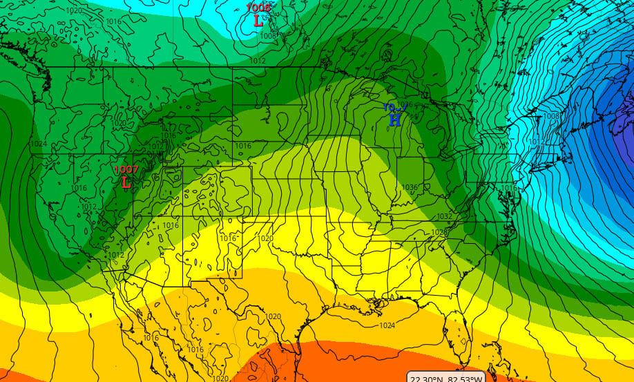
I hesitate to forecast warm weather after what we’ve seen, but somewhere along the line, all the cold air had to have escaped the freezer. Long range pattern is also showing a shift. This is the 500 mb (color-banded contours) and the surface pressures (smaller black lines) for Tuesday Feb. 10 according to the ECMWF. During the last week, we’ve seen a huge blocking ridge on the West Coast and a deep trough in the East at 500 mb (18, 000 ft.) This gets reversed by the 10th giving us a ridge in the middle of the US and a warm-up at the surface (surface contours show us with SE winds). My guess is that this is transitory and that we’ll revert back to some colder weather after mid-February.
Sat. Feb. 7 Low 41 High 56
Sun. Feb. 8 Low 38 High 61
Mon. Feb. 9 Low 47 High 65
Tues. Feb. 10 Low 51 High 69