- Wound Up on Weather
- Posts
- Early Saturday Thunder, then Cooler
Early Saturday Thunder, then Cooler
David Gilhousen
April 28, 2026

SUMMARY
Here’s a quick post on a day where I’m running late due to doctor’s appointments.
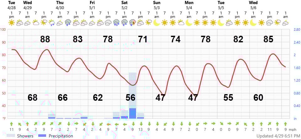
Our early season heat will last one more day, then the tail end of a weak cold front coming down from the north tomorrow night will gradually bring in some cooler air for Thursday and Friday. It will also give us a chance for showers and storms tomorrow evening through Thursday — but they will be scattered and not everyone will get them. Friday’s highs will be 10 degrees cooler than Wednesday — in the upper 70s.
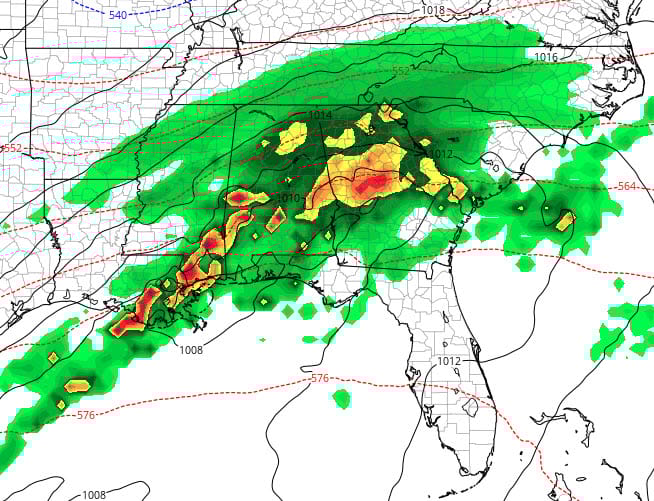
The big player arrives anywhere from 1 AM to 5 AM Saturday when a strong cold front will move a line or cluster of thunderstorms through (see the ECMWF 3-hour rainfall map ending at 7 AM Saturday - yellows and reds mean storms) We could get a widespread inch of rain, but the good news is that the rain should be over by 8 AM. The church I attend has big “Serve Day” events planned where hundreds will be outdoor landscaping around schools and helping build things - so that’s good news for this effort though the ground will be soggy.
Highs Saturday and Sunday will be well down into the 70s with morning lows on the Northshore in the mid-upper 40s! Mid-50s South. That’s cold for early May — reminds me of my Penn State days.
AT-A-GLANCE: SLIDELL
FORECAST DISCUSSION
The Foreca graphic, as usual, is too cold with the high temperatures during the warm spells. Otherwise, it captures the essence of it. Tomorrow evening’s rainfall will be heavier than shown across Washington Parish and Northern Pearl River County where storms are likely and they could see a half inch or more. Closer to I-12/I-10, we’ll be lucky to see much. Thursdays showers will be spotty — there could be a couple here and there at daybreak, then another one or two scattered near I10-12 in the afternoon. Thursday’s highs will be more reasonable, but still in the low 80s.
Friday should be be rain-free in the morning, but cooler. Showers should break out in the afternoon west of the city and across Tangipahoa and Western St. Tammany, but will hold off towards evening elsewhere. The big action will arrive after midnight. Thunderstorms, then, could have gusty winds but nothing else severe.
Then, enjoy a cooler and cloudy Saturday morning - a perfect time to wash and "wax” your car. Sunday and Monday will be real gems - enjoy.
LONG-RANGE RAMBLINGS
Another cold front should plow through early Thursday May 7 causing more storms and another few days of cooler weather.