- Wound Up on Weather
- Posts
- Extended Cold but no Hard Freeze
Extended Cold but no Hard Freeze
David Gilhousen
January 13, 2026

SUMMARY
Last week’s forecast of a long cold snap without the extremes still rings true, at least for the next ten days. Frosts or a light freeze are possible on a quite a number of the mornings, see the next section for timing. See Long-Range Ramblings for some insight beyond then in what could be a wild late January & early February.
Within this colder, mid-winter period, there will be our typical ups-and-downs. One will blow through tonight with some light showers giving us a warmer day tomorrow, then a cold front will roar through tomorrow evening giving us a considerably colder Thursday and Friday morning. Rinse and repeat for Friday night, Saturday, and Sunday. It’s our taste of New England where the locals say “If you don’t like the weather, just wait a day.”
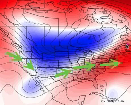
All this is courtesy of a series of upper air troughs moving through the east. This maps shows the jet stream winds forecast for tomorrow morning (blue represents the cold trough, the arrow show the upper wind). NW wind aloft keeps blowing the cold, dry air down from the High Plains. Fortunately, there’s not much snow cover in the High Plains so the surface air is not as cold as it could be plus the troughs keep moving on through quickly instead of lingering. That’s why we haven’t had a hard freeze since early November.

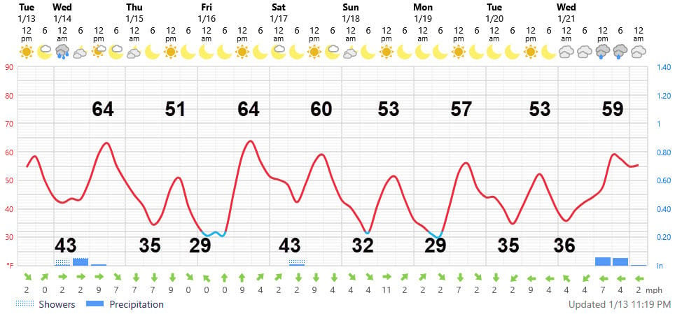
AT-A-GLANCE: SLIDELL
FORECAST DISCUSSION
The Foreca graphic shows three mornings where temperatures could reach freezing, Friday, Sunday and Monday. Frost is also possible on Thursday, Monday, and Tuesday mornings. As usual, add about 3-4 degrees for the more developed Northshore areas and maybe subtract a degree or so for a few interior frost pockets. Southshore lows should be a good five degrees warmer, but there could still be some scattered frost away from the Lake on the coldest days.
Light showers are possible late tonight or tomorrow morning before 8 AM. A band of light showers may also give us a few more drops pre-dawn Saturday morning. For most of us, the amounts will be barely measurable.
WInd chill will be a bit of a problem on Thursday and Sunday making the 30s feel like 20’s and the 50’s feel like 40’s. It’s a chance to use those (ugly Christmas ?) sweaters and jackets. .
LONG-RANGE RAMBLINGS
Expect the upper air pattern to change by the time we get to the weekend of Jan. 24-25. Models are pretty good in forecasting these major upper air shifts within two weeks in the winter. This long-range upper air forecast for Sat. Jan. 24 shows a trough in the West and a broad ridge in the East. This means we’ll be warming up, but the warm up could be short-lived, especially if an East Coast storm forms when the western trough swings eastward three days later. This would push cold air in our direction, perhaps the coldest of the season. It’s too early to say much for certain.
Thursday Jan. 22 Showers, Thunderstorms? Low 53 High 64
Friday Jan. 23 Partly Cloudy Warm Low 59 High 75
Saturday Jan. 24 Partly Cloudy Warm Low 64 High 74
Sunday Jan. 25 Partly Cloudy Showers Warm Low 65 High 75
Monday Jan. 26 Turning much colder. A freeze that Tuesday ?
My long-range guru, Joe Bastardi, thinks early February will feature up and down weather similar to what we’ve seen this week with another chance or two of frost. Then, he expects winter to break about mid-February.