- Wound Up on Weather
- Posts
- Good News Abounds
Good News Abounds
David Gilhousen
March 05, 2026

SUMMARY
Highs will move closer to normal starting next Thursday, and we will feature several days with above normal shower chances. In the long-range, there will be a few days that will feel cold. But…the danger of a freeze is over and the most recent model run’s have moved a bit warmer, so the chances of a damaging late March frost in rural Northshore area though not zero, look low.
In the short range, when I look for significant rainfall in the spring, I’m looking for organized thunderstorm systems. Sure, in the summer, pop-up scattered afternoon storms can dump a lot of rain — but this is not July. The pop-up ones will be featured tomorrow and Monday, but rainfall should be very light. Organized systems will arrive Saturday and Wednesday evenings, with the last one being more significant.
Here’s this Saturday’s system as forecast by the ECMWF. It shows a broken line of storms (yellows and reds) that self-propagates away from a front up in NE Louisiana and Northern Mississippi. That means it will dying the further east it gets as it moves away from its support mechanisms. The strong flow of air coming up from the Gulf should keep the front just north of the Gulf Coast.
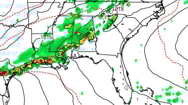
Wednesday evening’s system has a different look with a low near Shreveport and a line of storms to its east in our area. A strong system like this could bring severe weather to places like Arkansas plus a large part of Mississippi. Also, notice the dashed blue lines up in Northern Missouri and Iowa. That shows where the real freezing cold air is — too far away to get dragged down to us for a one-day cold spell.

AT-A-GLANCE: SLIDELL

FORECAST DISCUSSION
A usual, the Foreca graphic overdoes the days with rainfall but gets the days correct with the greatest chance of significant rainfall. Tomorrow afternoon’s scattered shower chances are about 30% on the Southshore and in the Gulfport-Biloxi area, 40% for Mandeville-Slidell-Picayune area and 50% further north and west. Most amounts will be dust settlers.
Saturday’s storms are more likely at or after sunset and should be over before midnight. Several tenths of an inch are possible. Sunday is the most challenging day to forecast. What’s left of the front north of the MS state line and will probably kick off a few thunderstorms — but will they make it to the Gulf Coast, or will they effect only areas 30 miles or more inland? I vote for the latter; the NWS thinks the former.
Monday is back to scattered, very light, mainly inland showers. Tuesday will probably be sunny and rain-free. The next system moving in Wednesday evening could dump that half inch to inch amount we’ve been longing for, but possibly have severe weather. Afterwards, temperatures come down to more normal March levels for next Thursday and Friday.
LONG-RANGE RAMBLINGS
The graphic below shows the ECMWF expected highs and lows for the six-day period after the above graphic. Another prominent cold spell is in store for March 17 and 18 with winter-like lows near 40 and highs only in the upper 50s to near 60 with wind. This bears watching, but current modeling came in warmer than the last few runs with some rural areas hitting the 38-40 deg range with wind. If this forecast is perfect, we won’t see frost. However, if it’s just a bit colder, rural areas who see lows as cold as Slidell’s airport might see some frost.
On the crystal ball side of the long-range…. Further north, winter will come back and have a hard time losing its grip through early April. But down here, I think its effects will be much more muted. Translation: Highs is the 60s to mid 70s with lows in the 45-55 degree range for late March. So late March will act more like early-mid March.

1