- Wound Up on Weather
- Posts
- Heat Wave Through Thursday AM
Heat Wave Through Thursday AM
David Gilhousen
August 17, 2025

SUMMARY
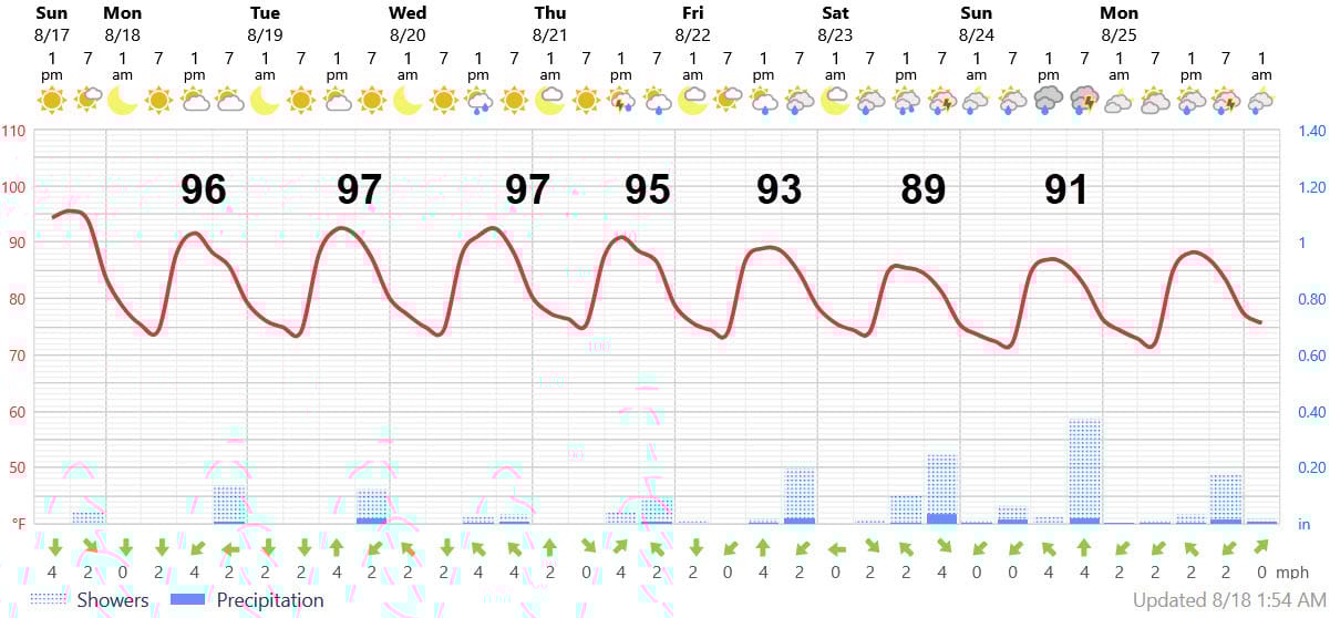
An upper level ridge is putting the lid on many of our puffy clouds trying to develop into showers and thunderstorms. Fewer showers and storms mean afternoon highs reaching the mid 90s everywhere and even upper 90s in inland areas. The script flips when the ridge (or heat dome) , moves out west allowing an upper level trough to approach from the north by late Thursday. Showers and storms will increase after then.
In the tropics, Hurricane Erin put on an amazing show of strengthening on Saturday going from a Cat. 1 to 5 storm in less than 24 hours north of Puerto Rico. Smaller storms, like Erin yesterday with its 7-mile wide eye, have an easier time of doing that. Today, an outer eye wall has replaced yesterday’s tight one creating a larger storm with Cat. 3 maximum winds. It still looks impressive on the imagery below. Erin will thread the needle between the Carolinas and Bermuda without making landfall, but throwing off a few fringe effects. More on this later.

Behind Erin lies another possible storm, and we’ll try to add a more reasonable voice to some of the speculation that you might have already seen in “Long Range Ramblings”.
AT-A-GLANCE: SLIDELL
FORECAST DISCUSSION
The Foreca graphic has the right idea with the extreme heat early and more moderating temperatures and better rain chances later. However, I’d quibble about the timing. Tomorrow should have a few more showers than today, but still below normal for an August day. Those that occur will happen later in the afternoon.
Tuesday and Wednesday should feature very few showers. Thursday will be a transition day with showers and storms expected later in the day. Friday, Saturday, and Sunday look to have above normal showers and storms.
LONG-RANGE RAMBLINGS
The Official NHC forecast for Erin is shown below. NHC has tended to be slightly to the right of the actual track in the last few days. Even with a track that’s close to the left edge of the cone, I can’t see Erin making landfall in the Carolinas given the upper air pattern and model agreement. However, the Outer Banks could see gale force gusts, huge breakers, several feet of surge, a ton of beach erosion, and possibly some coastal cottages being undermined. Not exactly beach weather for many places up and down the East Coast.

After Erin, another system in the Eastern Atlantic seems likely to develop somewhere near the Leeward Islands this Thursday (at the left side of the yellow thatched area below). NHC is giving it a 30% chance - that seems a bit low. What you might have seen on social media is a hurricane approaching Louisiana on August 27 resulting from this development. Let me explain why this seems unlikely and why a lot of things would have to fall into place for this to occur.

First, the scary graphic (not shown because I don’t want to scare) is courtesy of last night’s run of the American GFS model. The GFS tends to overdue development in the long-range and has recently performed about as badly as the N.Y. Yankees. The ECMWF and its AI model track the storm further north, closer to Erin’s anticipated track.
One reason why the path to the Gulf seems unlikely: The GFS shows the development taking place at the very SW end of NHC’s thatched track box. The ECMWF and its AI model both show the development further north. So, the development would have to be further south and slower (weaker) for it to move westward into the Eastern Caribbean for it to eventually get to South Florida and the Gulf. If development occurred even 150 miles further north on Thursday, the storm would likely follow Erin to the NW because of the huge hole it poked in the end of the Bermuda high.
Then, if the GFS was correct, it would also have to navigate around or survive the mountains of Haiti/Dominican Republic or Cuba to get into the Gulf. That’s a lot to ask.
While its always a good time to prep. for hurricane season, I’d estimate the chances of Louisiana/Mississippi/Alabama/NW Florida being threatened as 10-15%. We’ll learn more this week as we learn where it forms.
ALABAMA & NW FL BEACHES

Foreca graphic for Pensacola Beach shows some nice weather this week, then showers and storms for next weekend. Though the graphic shows a bit of rain on Thursday, I think the storms are even more likely there than us for late Thursday.