- Wound Up on Weather
- Posts
- Hot thru Wed, then cooler & wet
Hot thru Wed, then cooler & wet
David Gilhousen
April 26, 2026

SUMMARY
Gardeners among us are happy for Saturday morning’s 1-1.5” soaking that I alerted you to throughout last week. This mornings ½ to 1” second round was a welcome encore. No, I didn’t see that coming on Thursday, but it seemed likely yesterday morning when I glanced at my phone during a church retreat. Oh well, this 70-plus year old meteorologist has to have some down time.
Speaking about down time, the atmosphere will have some tonight through Wednesday morning. (Yes, there are a few showers developing near Poplarville heading in the direction of Gulfport-Biloxi, but they will die off or move offshore in a few hours) As we approach summer, down time typically means sunny, hot, and humid weather. You’ll feel like jumping in the pool tomorrow afternoon; but if you heat it, you’ll only have to do it again later in May because the heat will be broken later this week. This map shows the European forecast for late this Wednesday afternoon. A weak cold front, drawn as a dashed blue line will come through that evening with another line of showers and storms (greens, yellows, and reds).
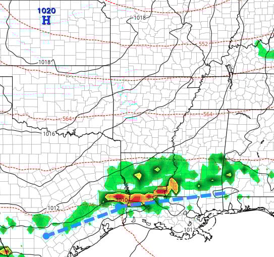
However, the front won’t get far offshore, so clouds will linger Thursday-Sunday as temperatures gradually cool off with Northshore lows in the 50s for Saturday - Monday. A low will develop on the front off Texas on Saturday that looks to give us a soaking rain with an embedded thunderstorm or two. Off-and-on rain could last through Sunday morning. This could be a real messy way to end Jazz Fest. Cumulative rain for the entire week could easily be an inch or two. This is the European forecast for late, next Saturday evening showing the “L” low and storms. Note however, that if you go 60 miles north or south of I-12/10, the rainfall totals and weather won’t be nearly as bad. So….I’m not 100% confident we’ll see the worst of this, but we should see rain.

AT-A-GLANCE: SLIDELL

FORECAST DISCUSSION
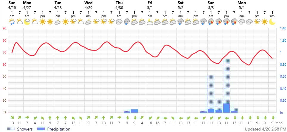
Again, the Foreca graphic underestimates the high temperatures. However, it does show the cooling trend nicely. Wednesday night’s showers/storms could come in several rounds and I wouldn’t be surprised to see more rainfall than the few tenths of an inch shown since the air will be so hot and humid. Rainfall chances are low for late Thursday and Friday but skies will be mostly cloudy. The Gulf storm looks to give us a steady, soaking rain with a few downpours in thunderstorms for Saturday. Then, wouldn’t you know it, net Monday May 4 looks to be a gem with sunny skies, less humidity, Northshore lows near 50 (Southshore, low 60s) and highs only in the mid 70s. Wow.
LONG-RANGE RAMBLINGS
Expect several beautiful days next week before another cold front looks to arrive. This is not unprecedented. Old timers will remember late April and May 1983 during a strong El Nino that featured cold front after cold front with “swimming pool” weather not arriving until late May. The El Nino developed late in ‘82 and gave a rainy, thunderstorm-filled spring with flooding in ‘83. Our El Nino is just developing, but we are shifting from a dry late winter and early spring to a wetter pattern for May and possibly June. After that, looking for a hot, drier than normal, mid summer.
Here, Tuesday-Thursday May 5-7 will feature highs in the low to mid 80s. Tuesdays lows will be in the low to mid 50s north, low to mid 60s south. Wednesday low’s low to mid 60s North, upper 60s South. Thursday’s lows near 70. Next shower and thunderstorm will be late that Thursday or Friday followed by another cool down.
ALABAMA & NW FL BEACHES
Foreca graphic for Pensacola Beach shows that late-week cooling trend with much wind and the potential for heavy rain next Sunday as that Gulf storm moves in their direction. Not great beach weather yet.