- Wound Up on Weather
- Posts
- How Cold will it get? Any frost?
How Cold will it get? Any frost?
David Gilhousen
March 15, 2026

SUMMARY
That’s the big question for those of us into gardening. The answer depends on where you live and how your backyard readings compare to those at Slidell’s airport. But first, let’s look at the current (1 PM Sunday) weather map from tropicaltidbits.com.
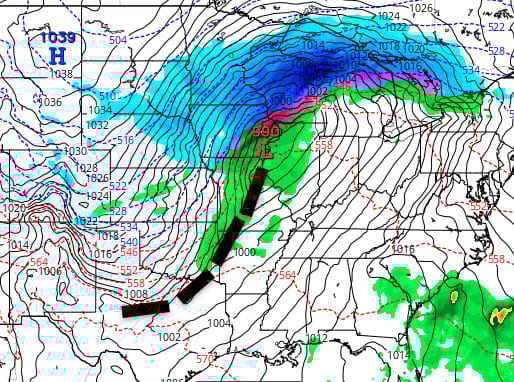
Everything is right on schedule with a strong low north of St. Louis heading to Northern Michigan and a cold front (my large dashed line) draped down through Branson to Dallas. A large blizzard is beginning to rage across Wisconsin while severe thunderstorms are breaking out from Illinois to Arkansas. The front should zip through here between midnight and 4 AM with showers and thunderstorms. The upper level support is further north so all I expect here is strong and gusty straight-line winds as opposed to anything tornadic, but keep your NOAA Weather Radio or cell phone handy just in case. Rainfall amounts should be light - a few tenths of an inch.
It will be back to winter again tomorrow through Wednesday morning. Highs tomorrow will struggle to reach the mid 50s but with the wind it will feel like the 40s. Wind should stay up through evening before gradually coming down to a gentle breeze by morning. Tuesday morning’s temperatures will flirt with freezing (about 32) in some of the normally colder inland areas (Folsom, Bush, Necaise…). For many areas of the rural Northshore that read about what Slidell’s airport does, 33-34 seems about right. For those of us in more protected, densely populated areas of the Northshore, 35-38, and near 40 south. I think you’ll see very little frost because of the wind and low humidity.
On the other hand, Wednesday morning has a greater chance of frost in many rural areas that will reach 34-36. More protected areas of the Northshore should stop in the 39-42 range without frost. So, cover any annuals that you transplanted if your nightime readings are about what Slidell’s airport reads. Hardy vegetables like cabbage, cauliflower and broccoli should take this. You can also water the ground since this adds heat.
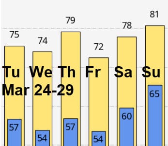
AT-A-GLANCE: SLIDELL
FORECAST DISCUSSION
The Foreca graphic looks like someone pushed you over a cliff before you take five steps to climb back out. Seriously, the FORECA TEMPERATURES ARE TOO LOW. This is the worst temperature forecast I’ve seen from them all year. Maybe they think the airport in Slidell has moved or that the sun heats the ground about as strongly as it does in Finland (where Foreca is produced). So, USE MY NUMBERS INSTEAD OF THE GRAPH.
The only rain is with the front tonight. After that, it’s nothing but sunny weather and spring-like temperatures from Wednesday afternoon on.
LONG-RANGE RAMBLINGS
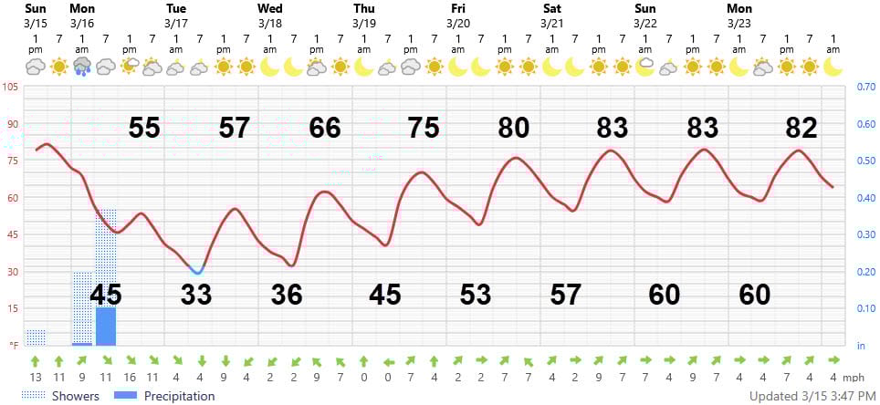
Expect the nice weather to continue for about a week after the end of the Foreca graphic. The ECMWF temperatures are presented below. No significant shower threat exists in this time frame. Beyond this period, I think we will have another cold snap in early April, but lows will stop in the low- to mid-40s.