- Wound Up on Weather
- Posts
- Late November Weather Arriving Wednesday
Late November Weather Arriving Wednesday
David Gilhousen
October 26, 2025

SUMMARY
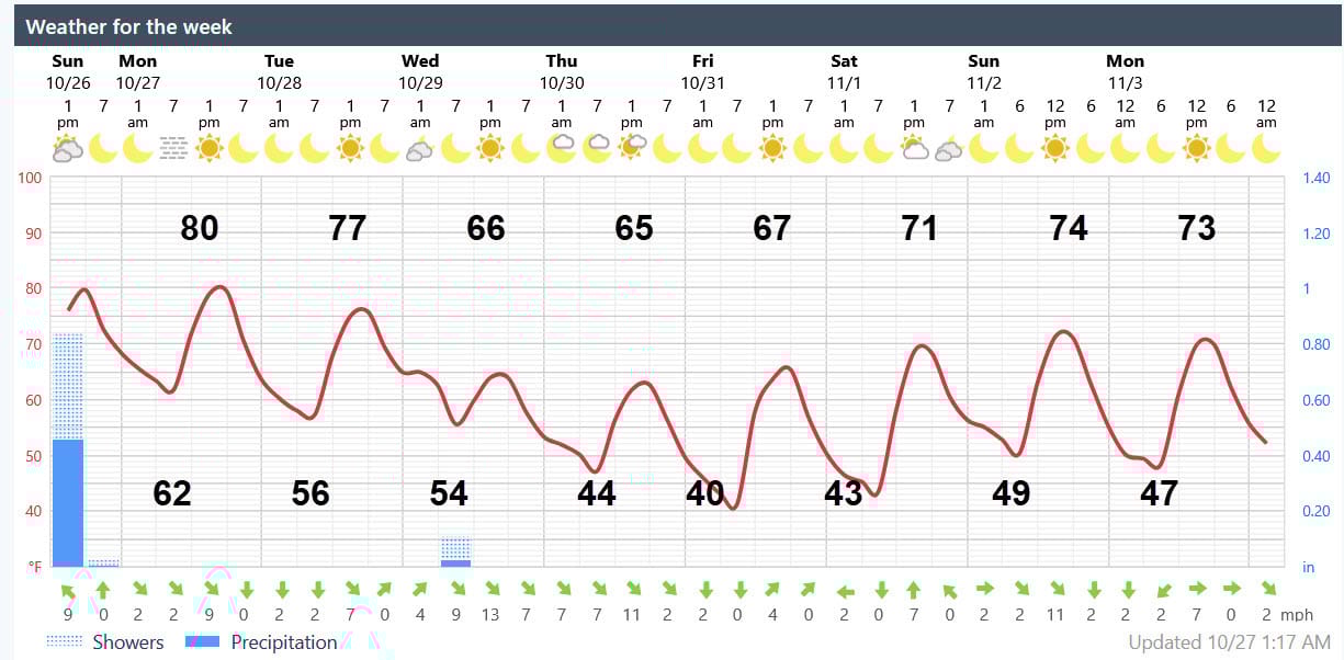
After a top-notch Monday and Tuesday with cool mornings and warm afternoons, the much advertised cold front will arrive with showers in the pre-dawn hours of Wednesday. But, unlike this weekend when I received 2.5” and a few locations from Houma-Kenner-Bogalusa possibly had small tornadoes, this front will come through quickly giving us only a few tenths of an inch at night without the severe weather threat.
Afternoon highs will stay in the 60s for Wednesday - Friday while lows plummet to the low 40s in many Northshore locations for Friday and Saturday morning. To put this in perspective, the average high and low temperatures should be 76 and 56. Wasn’t I sweating and swimming just 10 days ago?
Winds should gust to 25 mph over land and 35 over water on Wednesday and Thursday before dying off on Friday. Trick-or-treat temperatures will range from near 60 close to sunset to near 50 at 9 PM, especially in inland areas. Time for you to get that hot apple cider and fire pit going while the kids get their sugar high. See the next section for more details.
My “Long Range Ramblings” section will discuss Hurricane Melissa and an outlook for November.
AT-A-GLANCE: SLIDELL
FORECAST DISCUSSION
The Foreca graphic looks good except for some minor temperature tweaking. I think the cold air will move in a little faster than expected and winds should be a bit higher - the graphic doesn’t reflect the gust factor.
For tomorrow, some early morning fog is possible, then a few scattered clouds before completely clearing. Otherwise, Monday and Tuesday will be gems if you like cool mornings and warm afternoons without a lot of humidity.
Winds should keep the low temperatures pretty much the same at most Northshore locations for Wednesday and Thursday. Southshore lows should not get below the low 50s because the Lake is still warm. Expect gusty winds on the bridges and near the water because of the lake - air temperature difference.
As the winds die down on Friday and Saturday, we’ll see some big low temperature differences within the Northshore. Rural inland locations could see some upper 30s, though I doubt you’ll see frost. My more protected, deeply suburban citrus grove could stay at 45.
LONG-RANGE RAMBLINGS
Thanks to another reinforcing shot of cold air coming in around Monday, the week of November 3-9 should stay fair and pleasant with temperatures just a few degrees below normal, lows will range from the upper 40s to low 50s in rural locations, highs 72-75. After that, expect a warm up with our next rain chance the week of Nov. 10, but a return to colder weather Thanksgiving week.
Long-range gurus expect a tough winter in the Great Lakes and Northern Plains with some of those cold spells impacting us, even though, in the mean, we may have a normal or slightly warmer than normal winter. They expect the brunt of the cold air to head south to Texas and east to New York rather than southeast.They expect winter to start early with December well below normal. Don’t even ask me about snow — no one can forecast that more than a few days ahead of time in the Deep South. We were lucky to nail that forecast last year.
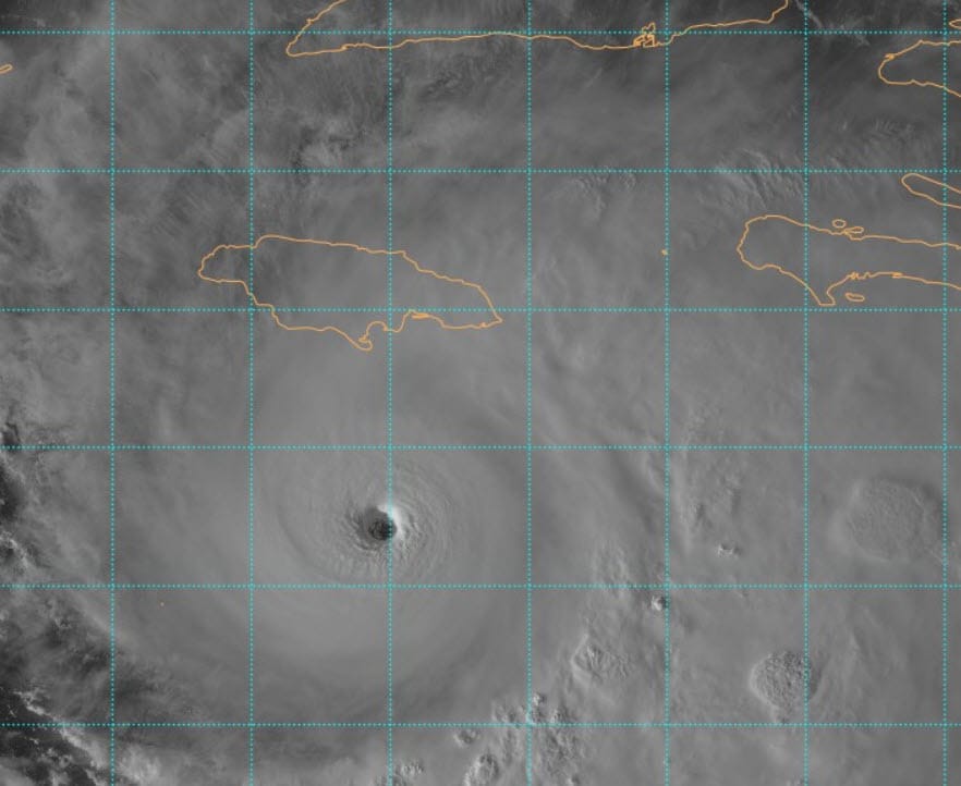
On to Melissa. You don’t need a weatherman to tell you there will be a tremendous disaster in Jamaica from the worst storm they’ve ever seen. It’s presently a strong Cat. 3 and strengthening as it moves slowly to the west before curving north into the middle of the island on Tuesday. Expect mudslides, flooding, and all sorts of damage caused by the wind. Time to pick a charity and the amount you want to give if you are able.
After Jamaica, southeast Cuba is next where our Guantanamo Bay facility will take a serious hit. Large mountains there mean big rainfall. Then, several of the southern most Bahamas and even Bermuda may get some impacts. By the way, I wouldn’t blame this on climate change. The Caribbean sees a late season, slow moving, major hurricanes like this every 30-50 years and there have been some doozies.