- Wound Up on Weather
- Posts
- Light to Moderate Freeze Tuesday
Light to Moderate Freeze Tuesday
David Gilhousen
February 22, 2026
In partnership with

SUMMARY
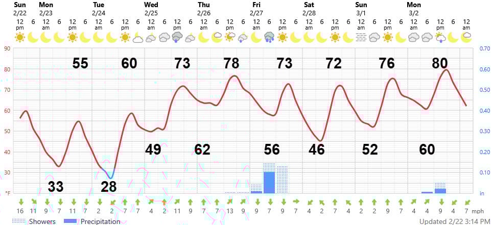
Because the East Coast blizzard is developing a little deeper and moving more slowly up the coast rather than zipping out, more cold air will be pushed south in its wake. Temperatures here will be a degree or two colder than I expected. Tonight’s lows will be 33-35 on the Northshore, and upper 30s South. Because the winds will keep blowing,, expect little frost. Tuesday morning, however, will be a different story.
This is the ECMWF map for Tuesday morning showing the cold, high pressure area right over us (maps courtesy of Tropicaltidbits.com) . That’s bad news because the winds will go calm and temperatures will plummet with a light to moderate freeze and widespread frost on the Northshore. Expect 27-30 in many suburban and rural areas of the Northshore that typically agree with the NWS Slidell airport observation. If you live in one of those normally colder locations and your pipes are not wrapped, consider running your water. On the other hand, in more protected Northshore locations, temperatures should stop in the 31-33 range (Southshore 34-37) but frost will still be widespread everywhere.

Feel Better, Without Overthinking It

Most of us don’t need a complicated routine. We just want to feel good, stay energized, and not think too hard about it.
AG1 Next Gen is a clinically studied daily health drink that supports gut health, helps fill common nutrient gaps, and supports steady energy. One scoop in cold water replaces a multivitamin, probiotics, and more, so your routine stays simple.
Start your mornings with AG1 and get 3 FREE AG1 Travel Packs, 3 FREE AGZ Travel Packs, and FREE Vitamin D3+K2 in your Welcome Kit with your first subscription.
AT-A-GLANCE: SLIDELL
FORECAST DISCUSSION
The Foreca graphic looks good except for that shower symbol on Wednesday with no rain amounts given. I’ll break the tie in this bipolar behavior by saying that it won’t rain on Wednesday.
The warm up starts as soon as the sun melts the frost on Tuesday, but will be really noticed when we pop back into 70s on Wednesday and upper 70s on Thursday. Bottom line: When you wash your shorts, don’t bury them in the bottom of the drawer — you’ll need them soon enough.
The next chance of showers will be Friday morning. The ECMWF forecast for Friday morning shows a line of showers with a cold front that will move through. However, we’ll be on the tail end of the line, so showers will be scattered and amounts light. Better rain chances will be in Pearl River County. Also the high is weak and of Pacific origin so temperatures won’t drop much and a lovely weekend is in store.

LONG-RANGE RAMBLINGS
The atmosphere usually gets boring for a good week or ten days after a big event like the East Coast blizzard. Eventually, cold air will build back in Western Canada and they will send it towards the States, seeking revenge after today’s hockey game. The good news is that the upper air winds will be moving it more towards the Mid-Atlantic states than the Deep South. We might just get in on the southern end of one of these cold Canadian highs, about the 8th or 9th of March as shown below. The ECMWF forecast highs and lows are shown here with showers more likely in the Friday-Saturday (March 6-7) period
