- Wound Up on Weather
- Posts
- Little change to Sunday's Forecast
Little change to Sunday's Forecast
David Gilhousen
April 14, 2026
Tired of news that feels like noise?
Every day, 4.5 million readers turn to 1440 for their factual news fix. We sift through 100+ sources to bring you a complete summary of politics, global events, business, and culture — all in a brief 5-minute email. No spin. No slant. Just clarity.

SUMMARY
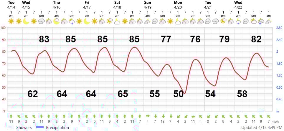
A statement like that won’t attract viewers, but I not a TV weather guy. Warm, windy days with a bit more humidity will continue through Saturday. Highs will creep up to the mid 80s for most of us — upper 80s to perhaps 90 in some of the normally hotter inland locations to our NW like Folsom. A cold front will come through Sunday morning shifting the winds around but with very little rain, if any. Sunday-Tuesday will feature cooler temperatures with highs in the mid-upper 70s and morning lows in the 50s. Next chance of signficant rain is probably a week from Thursday, April 23. Read on for more details.
AT-A-GLANCE: SLIDELL
FORECAST DISCUSSION
The Foreca graphic brings in a bit colder air Sunday- Tuesday than I think will happen. So again, look at my numbers not the curve. Otherwise, I agree with the precipitation — a very dry forecast.
One thing to note: There will be more clouds in the next week. Partly cloudy skies will be the norm from Friday afternoon through Saturday evening. A line of light showers will arrive in the pre-dawn hours of Sunday in Tangipahoa, Western St. Tammany, and Washington Parishes. That line will start falling apart by the time it reaches the New Orleans-Slidell-Picayune area at about daybreak. Even though it may not rain…Clouds will persist through early to mid afternoon before clearing. Monday will be partly sunny.
LONG-RANGE RAMBLINGS
The European model keeps insisting on several rounds of thunderstorms from Thursday April 23-Saturday April 25 giving us several inches of rain. The other models, however, have backed off. I wonder if this is the case of an upper air system that was over Asia in a data rich area a few days ago and all models detected it. Now that it has migrated into the Pacific in a data void area, most models don’t see it. The European model seems to have better “muscle memory” in correctly keeping these systems in tact even if there’s no data supporting it.
So, if the European is correct. next Wednesday will be warm with lows in the upper 50s and highs in the low 80s. Then, Thursday-Saturday will be humid with scattered thunderstorms lows upper 60s, highs upper 70s. The European favors a wet May.