- Wound Up on Weather
- Posts
- Locally Heavy Rain Wed-Thurs?
Locally Heavy Rain Wed-Thurs?
David Gilhousen
May 04, 2025

SUMMARY
Our beautiful April-in-May weather will only last through Monday before a wet pattern entrenches itself in our area. Return flow of deep Gulf moisture, some surface boundaries, and an upper level flow will all be pretty much stuck in our area from Tuesday-Thursday, and maybe longer. That means multiple rounds of showers and storms, with the exact timing difficult to predict.
The heaviest rains look to happen from Wednesday-Thursday and we will have to watch for flash flooding when storms redevelop and move over the same area. These events are very localized with part of a parish or county getting 5” or more in a few hours while communities 20 miles away get only a few tenths of an inch or less. The pattern and anticipated moisture gives us the threat of an event like this — so I agree with my Weather Service colleagues here in mentioning this threat. Keep up with the weather as we get towards Wednesday.
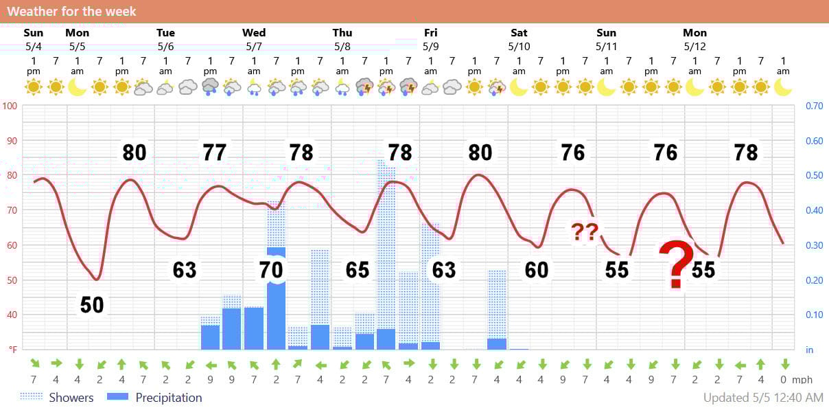
AT-A-GLANCE: SLIDELL
FORECAST DISCUSSION
1) Scattered showers mostly on Tuesday morning and some locations could get a few tenths. A mostly cloudy start might feature some breaks in the clouds in the afternoon. If so, temperatures could hit 80, if not 77.
2) Wednesday will see a cluster of thunderstorms with heavy rain moving in during the pre-dawn hours. Then, storms will end in the morning and start again, perhaps in the same areas that evening. Most likely areas for the heavy rain seem to be the Northshore and Coastal MS as opposed to the Southshore, but I’ll give it another look on Tuesday. Humid with temperatures in the 70s.
3) Recent models are predicting a shift in the heavy storms to the mouth of the MS River and further east. This would leave only scattered light rain in our area for part of the day which means the Foreca graphic overdoes the rain. BUT, it’s a real close call that bears watching.
4) Friday looks half-way decent with some sun and maybe another thunderstorm later in the day, 80 degrees or low 80s seems likely.
5) Foreca graphic indicates a decent Mother’s Day weekend, but this is a very low confidence forecast. Though the European and German models indicate this, other models do not. Personally, I’ll buy into the cooler Foreca temperatures, but think that there will be a mixture of clouds and sun with some scattered showers through the weekend. Not bad, but not beach weather.
LONG-RANGE RAMBLINGS
So much for a dry May! Most of us on the Northshore should see 2-3” of rain this week (though some could get much more), but after that, nice weather starts next Monday and should last for a week with highs more like normal — in the 80s.
Yes, I have been working on an updated hurricane season outlook and I should send that out as a separate newsletter tomorrow unless I feel I need to post more important news about the weather this week.
ALABAMA & NW FLORIDA BEACHES
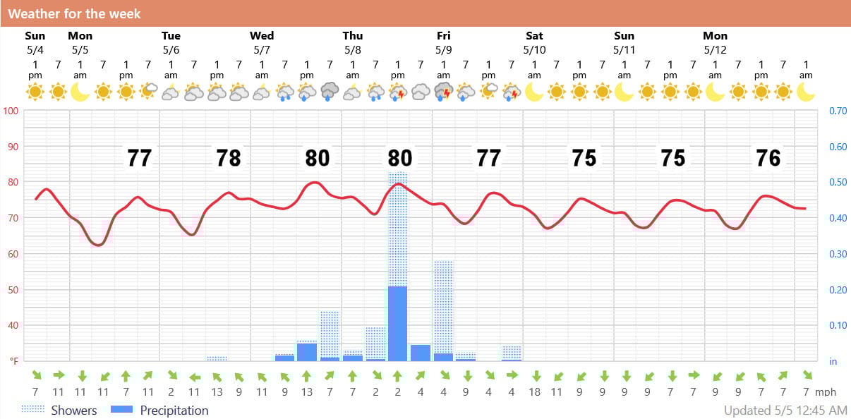
Foreca graphic for Pensacola Beach shows more of a concentrated shower/thunderstorm event on Wednesday and Thursday followed by cooler afternoon temperatures for next weekend. However, like here in Louisiana and Mississippi, the weekend outlook is highly uncertain due to slow moving systems. Personally, I see at least a mixture of clouds and sun there for next weekend.