- Wound Up on Weather
- Posts
- Lovely weekend, then back to late September
Lovely weekend, then back to late September
David Gilhousen
October 09, 2025
In partnership with

SUMMARY
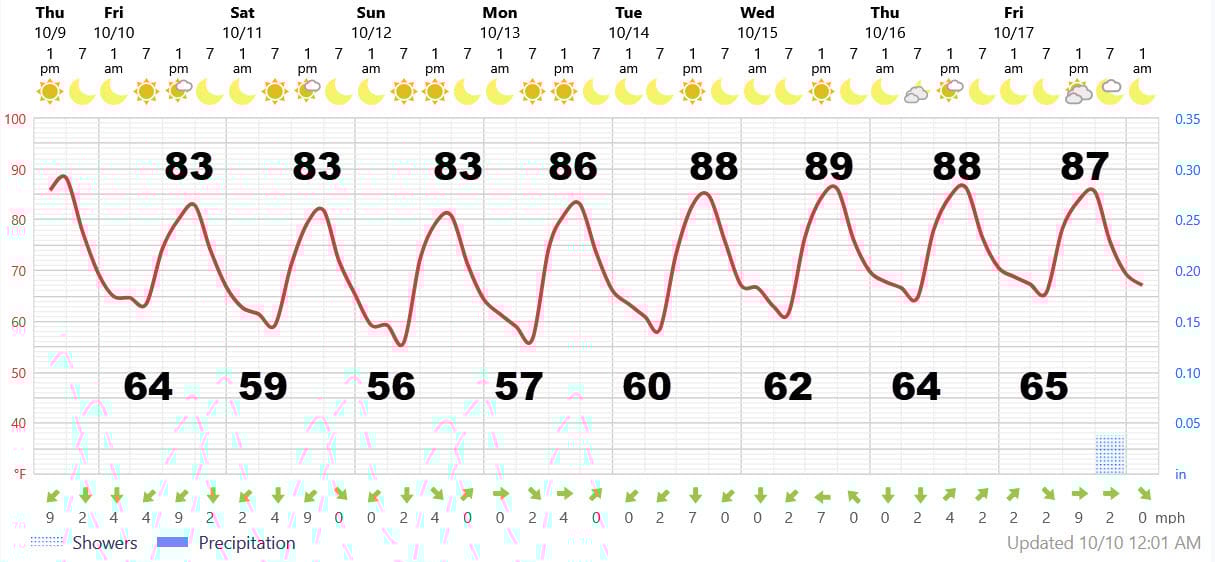
Thank heavens for back doors. Somewhat cooler and drier air is filtering in for the weekend from the Northeast. The air will feel amazing with sunny skies and lows mainly upper 50s on the Northshore and highs 83-84.
Though the sunny weather will continue for a week, the temperatures will rise starting with mid-day Monday. Highs should get back into the upper 80s to near 90 with lows low-mid 60s. Still not mid-summer heat and humidity, but a good 5 degrees warmer than where we should be for mid October. Unfortunately, I can clearly say when the next cold front will arrive. See my Long-Range ramblings for some speculation.
Drought may be an issue if you didn’t get an inch of rain with the last system. In fact, areas in Western Louisiana and near Houston might run a wild fire danger next week.
The hurricane season as far as we’re concerned is over. Yes, there have been years with no hurricanes in the Gulf - the last one was 2015.
Looking for unbiased, fact-based news? Join 1440 today.
Join over 4 million Americans who start their day with 1440 – your daily digest for unbiased, fact-centric news. From politics to sports, we cover it all by analyzing over 100 sources. Our concise, 5-minute read lands in your inbox each morning at no cost. Experience news without the noise; let 1440 help you make up your own mind. Sign up now and invite your friends and family to be part of the informed.
AT-A-GLANCE: SLIDELL
FORECAST DISCUSSION
The Foreca graphic captures my thinking with a tweak or two for temperatures. On the Southshore, expect similar highs but lows this weekend will be mid 60s away from the Lake, upper 60s near the Lake. On the flip side, some inland areas could see mid-50s this weekend. No rain is expected through the period.
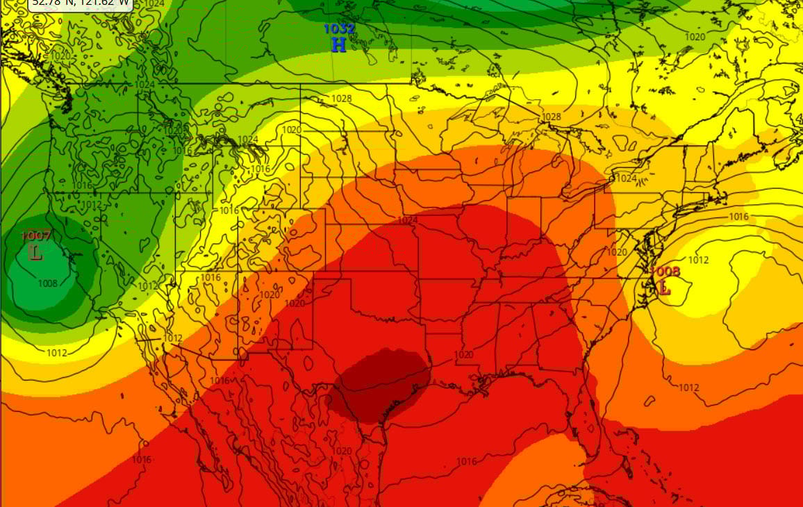
.The reason for this slow moving sameness: An upper air omega block. You can almost see that greek letter in the colored contours at the jet stream level on this European model forecast for next Tuesday morning. Low level flow (the solid line) is still bringing in air from the northeast but temperatures will rise as air sinks under the building upper air high. Though we won’t like the added heat, it could be worse. The Coastal Mid-Atlantic states will be stuck with that windy, rainy, cool storm system for three or four days.
LONG-RANGE RAMBLINGS
The challenge is the timing of when the omega block breaks down and what follows it. The European AI model bring in a trough and a surface low into the heartland (MIssouri-Tennessee) by the middle of the following week, approximately Aug. 22. That brings a cold front our way. The ECWMF stubbornly insists on a straight E-W upper air pattern keeping the cold air up north and therefore no cold front that week.
Hmmm….I’m leaning in the direction of a compromise, maybe a cold front about Aug. 25 for no good reason except that I’m tired of this endless summer. Also…the summer can’t go on forever.
ALABAMA & NW FL BEACHES
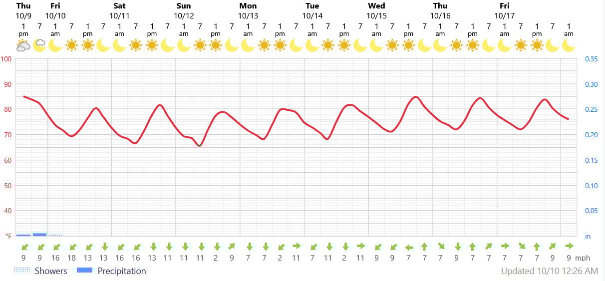
Foreca graphic for Pensacola Beach shows just beautiful weather after the winds die down mid-day Sunday.