- Wound Up on Weather
- Posts
- Monday Freeze; Christmas Wk Warmth
Monday Freeze; Christmas Wk Warmth
David Gilhousen
December 11, 2025

SUMMARY
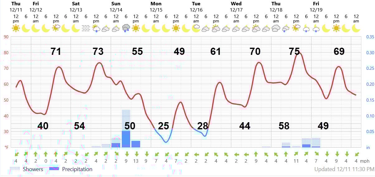
Honestly, this one snuck up on me. The Canadian high behind the strong cold front that will come through Sunday morning will be a bit stronger than I anticipated. That means there will be stronger winds blowing the cold air southward. Temperatures will plunge from low 70 warmth on Saturday to a windy 55 degree Sunday and then a mid 20s freeze on Monday. Monday’s highs will stay in the 40s and then Tuesday should feature widespread frost.
The forecast map for Sunday morning shows the front and the high which will move from North Dakota to Kentucky. The green arrows show the surface winds behind the front which will blow the cold air in.

After that, it’s almost all up hill concerning the temperature. In fact, it will be a steep climb since the cold will be short-lived: Wednesday’s highs will be near 70 and temps could reach the mid 70s by next Thursday. Flu weather for sure. After a one-day cool down for 5-10 degrees for next Friday, it’s an extended warm and dry spell courtesy of a pattern where the cold will be in the west and the warmth east of the Rockies. Read on for some important details such as showery periods and fog.
AT-A-GLANCE: SLIDELL
FORECAST DISCUSSION
The Foreca graphic screams “mountains ahead”, which is why I drive a Subaru. After a chilly night tonight, tomorrow will be noticeably warmer reaching the low 70s. It will be just a gorgeous sunny day with that touch of fall color. Then, watch out for fog Saturday morning. It’s a classic case of light winds blowing off the warmer, deep water Gulf onto colder land (or colder lake or sound water). After the fog clears, it should still reach the low 70s.
Then, the front arrives with brief showers ahead of it in the wee hours of Sunday morning. Rainfall amounts could range from a few hundreths to a few tenths. It will turn windy and the temperatures won’t rise more than a few degrees, holding in the mid 50s. Temperatures will plunge to freezing by about 3 AM Monday and reach the mid 20s for lows in most rural and suburban Northshore areas. More protected suburban areas should be 2 or 3 degrees warmer, say upper 20s. Southshore lows near freezing (32-35), but the wind should keep frost from forming there.
Tuesday morning’s low should show more variation since the wind will be calm. Rural northshore areas could reach 27-28, more protected Northshore areas near freezing, and 40 degrees South. However, there should be widespread frost on the Northshore.
After that, warmth will quickly return, but with a chance of showers on Thursday.
LONG-RANGE RAMBLINGS
Expect an extended warm and dry period from Saturday Dec. 20 through Christmas with highs in the 70s and lows near 60. No, we’re not done with winter yet, but this should be a relatively calm period.