- Wound Up on Weather
- Posts
- Multiple rain chances, light freeze
Multiple rain chances, light freeze

SUMMARY
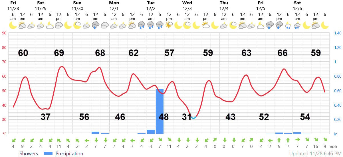
Subtitled “If you don’t like the weather, wait a day” for an active weather pattern. After a cool Black Friday, and a warmer gem of a Saturday, a cold front approaches slowly from the west early Sunday. Follow this sequence of events using the graphic below produced by the National Weather Service.

Round 1 for rain chances features a cold front with showers coming into Tangipahoa and Washington parishes perhaps as early as 1 AM on Sunday. But the rain-making mechanisms will be dying off the further east the showers go. By the time the showers reach Slidell in the wee hours of Sunday morning, they could be breaking up and might die out completely by the time they reach Biloxi by mid-day Sunday. The cold front does make it offshore where it stalls.
Round 2 features a storm that will form on the front and press towards us late Monday. Recent model runs show the storm moving north of us meaning that the heaviest rains will fall over Central Mississippi. However, this still does seem like it will be our best chance for a decent 1” rain, which will include thunderstorms, in a long time.
After that, cold air will move in with windy 50 degree weather for Tuesday and a morning low near 30 on Wednesday for a light freeze. After that, count on a slow warming trend for Wednesday afternoon on Thursday before our next system late next Friday Dec, 5. Beyond that, the long-range is way too muddled for me to tackle on this, the blackest of Fridays. Translation: I’d rather watch football…..
AT-A-GLANCE: SLIDELL

FORECAST DISCUSSION
Just one look at the Foreca graphic makes you wonder whether it is a dizzying mountain road. The temperature looks almost perfect, but Sunday’s rain might be shifted a little earlier, especially if you live in areas west of Slidell.
Sunday’s rainfall will be earlier and a bit more substantial (1/2” ?) in places like Western St. Tammany, Tangipahoa and parts of Washington Parish. Rainfall chances should end by early afternoon. Then, cloudy conditions prevail for Sunday afternoon through Monday morning.
The timing of the next system is a bit fuzzy. Some models move showers and thunderstorms in as early as noon on Monday, while others hold it off until evening. It should be over before daybreak on Tuesday. Several batches of showers and storms are possible which makes me think that we could well see that elusive one-inch rain.
Tuesday will feature clearing skies, windy, and cold temperatures with highs staying in the 50s. Winds will die down and temperatures will plummet into the 29-34 degree range meaning that rural Northshore areas will see a light freeze and even densely suburban areas should see a frost. Southshore will see upper 30s with a few less developed areas away from the Lake could see a frost.
Wednesday afternoon and Thursday will be nice with moderating temperatures.