- Wound Up on Weather
- Posts
- NC may get Tropical Storm; we're OK for now
NC may get Tropical Storm; we're OK for now
David Gilhousen
August 03, 2025

SUMMARY
As expected, the tropics should pick up later this week, but the good news is that I’m not expecting anything to effect us for at least 10 days. A storm is presently getting cranked up east of Cape Hatteras, but it is heading out to see as shown by the single arrow on the satellite imagery. The National Hurricane Center (NHC) will probably name this, but it may well stay as a tropical storm because it doesn’t have pure tropical characteristics. may struggle with wind shear, and have only modest upper air support.

Of more importance is the wave that came off Africa a week ago and is now well north of Puerto Rico. It now looks like it won’t track into the Gulf, but could threaten North Carolina. I’ll be discussing this in “Long Range Ramblings”.
Closer to home, a little low pressure area just north of Mobile pushed a weak front through our area yesterday. Today featured almost no showers, a nicer morning and somewhat less humid air. Too bad this isn’t late September, or we might have really noticed it. Expect conditions to gradually get back to the normal showery summer by mid week.
AT-A-GLANCE: SLIDELL

FORECAST DISCUSSION
The Foreca graphic doesn’t show much. Somehow it expected a lot of rain today in Slidell, which I certainly didn’t forecast. Tomorrow, I think it overdoes the potential. I see 30-40% rain chances along I-10 from Slidell to Biloxi, maybe 20% elsewhere with modest amounts. Then, try as I could I couldn’t see any clear pattern to the showers. Call it typical summer with 30-40% chance of mainly afternoon showers and thundershowers. When you add it all up, we might get a half inch to an inch for the entire week. High temperatures pretty typical too, 90-92.
LONG-RANGE RAMBLINGS
The interesting question is what happens to the wave north of Puerto Rico. Though the current NHC outlook given below shows only a 20% chance of development (yellow area off South Carolina and Georgia), the American GFS, the German ICON, and the European AI model show development on Wednesday about where my arrow curves on the satellite image above. These are really different models and development is only three days off — so 20% seems low. I’d rate this as higher than 50%.
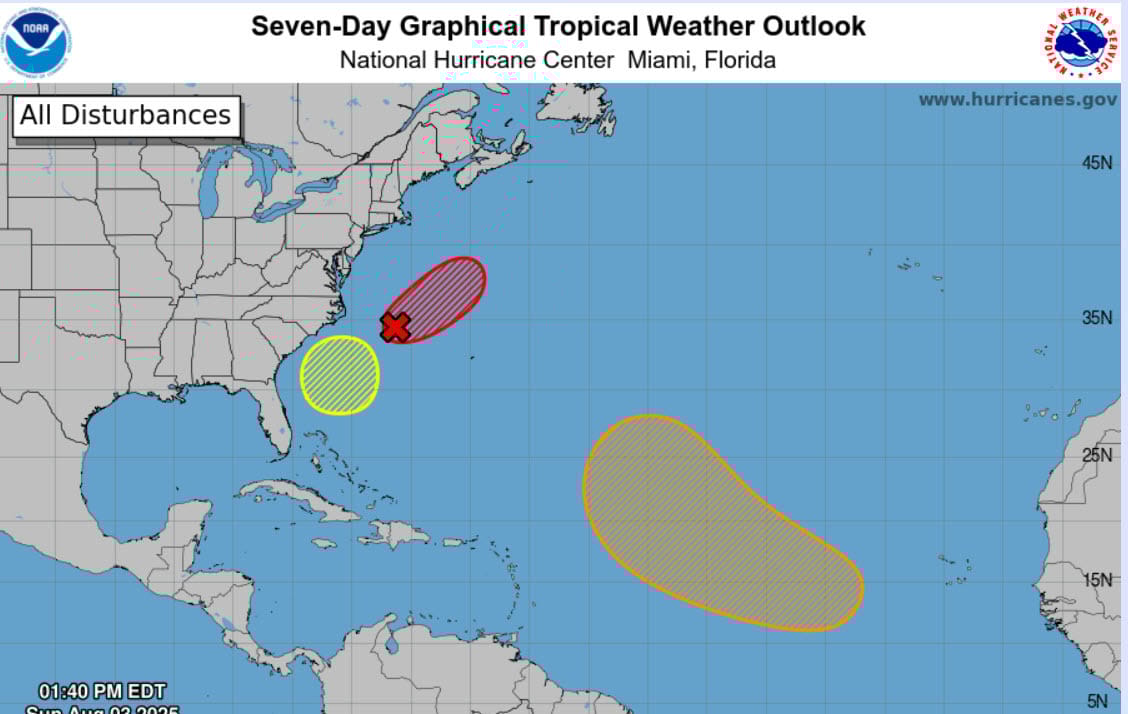
To show you what one model is doing, the German ICON on Thursday AM shows a small system heading towards the Morehead City, NC or Outer Banks area by this weekend. There’s no particular reason I’m picking this one, just to show you about where this could end up.

Again, for us, I don’t see anything on the horizon in the next 10 days. However, I am expecting an active period in the Atlantic to continue for the next three weeks. So, it’s possible we could get a threat in the Gulf in two weeks.
ALABAMA & NW FL BEACHES

Foreca graphic for Pensacola Beach shows the really wet period continuing through Thursday, then maybe some minor improvements.