- Wound Up on Weather
- Posts
- "Sunday Mornin' Rain is Fallin' "
"Sunday Mornin' Rain is Fallin' "
David Gilhousen
April 16, 2026
Tired of news that feels like noise?
Every day, 4.5 million readers turn to 1440 for their factual news fix. We sift through 100+ sources to bring you a complete summary of politics, global events, business, and culture — all in a brief 5-minute email. No spin. No slant. Just clarity.

SUMMARY
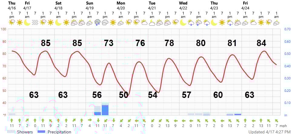
Time to start singing the oldies because like Easter, another Sunday morning cold frontal system is moving through. This one won’t be nearly as prolific as our Easter storm, but the odds of getting a tenth of an inch to a half inch across the Northshore have increased. The good news is that the rain will be over early — by mid-morning and the skies will break out by mid-afternoon.
Then, it’s back to some lovely early spring, sunny weather with lows in the 50s and highs in the 70s for a few days before warming up. The long-range theme is still the same, but the timing has been delayed — so read on.
AT-A-GLANCE: SLIDELL
FORECAST DISCUSSION
The Foreca graphic is a little on the cool side of what I’m forecasting, but notice that the rainfall amounts have increased from piddly to noticeable for Sunday. The larger rainfall totals should be to our west with the River Parishes getting perhaps an inch. Remember that the blue bar at 1 pm Sunday means a 6-hour total from 7 am. In this case, all of that rain will be early, before 10 AM. Tomorrow (Friday) should have plenty of sun and enough sea breeze to make 85 quite tolerable. Saturday morning should be partly sunny, but clouds will increase by afternoon.
Unless you are trying to heat your swimming pool, the spell of cool weather with lower humidity will be delightful. Monday morning’s low of 50 could easily be 48 in some rural inland locations. We won’t see temperatures that chilly again until October. Notice that the Thursday rain has been delayed into the long-range. Humidity will increase by Friday April 24.
LONG-RANGE RAMBLINGS
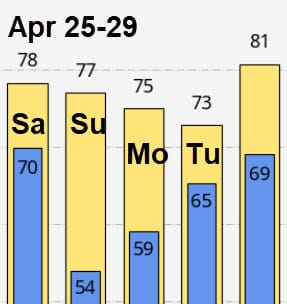
Most models are gravitating towards showers and storms moving through Saturday morning April 25 followed by another cooler day or two. The ECMWF temperature forecast is shown below.
The general theme seems to be a warm May with some significant shower and thunderstorm episodes — enough to keep us out of drought and end up a bit above normal. May is too early for those pop-up, scattered afternoon storms - so these would be caused by systems approaching from the north. May rains are really tricky to forecast since they involve small systems where it’s a deluge in one part of the parish and bound dry in another. We’’ll get the Pensacola Beach forecast going by May.