- Wound Up on Weather
- Posts
- Roller Coaster Weather
Roller Coaster Weather
David Gilhousen
November 02, 2025
In partnership with

SUMMARY
Yes, the parish (or county) fairs are over, but starting this coming weekend, roller coaster weather is about to begin. A few warm days will be followed by a few cold ones courtesy of some large waves in a fast moving jet. However, I’m getting ahead of myself. This week will feature a few cold mornings followed by a gradual warm-up. Then, the next cold front will move through next Sunday.
Temperatures will plummet from near 80 on Friday and Saturday to near 40 by next Monday the Nov. 10. The fun (and hopefully, not the flu) has just begun with another cycle for the following week as I explain in “Long Range Ramblings”.
In the rainfall department, don’t expect much with next weekend’s front. I’m confident that the totals won’t amount to much — maybe a tenth of an inch — but the timing is not certain yet. The reason for the piddly precip: Very little return flow from the Gulf. On the other hand, long-range models are in reasonably good agreement for out to two weeks (Miracles do happen) and they are pointing towards a heavier thunderstorm event on or about Sunday Nov. 16.
Your career will thank you.

Over 4 million professionals start their day with Morning Brew—because business news doesn’t have to be boring.
Each daily email breaks down the biggest stories in business, tech, and finance with clarity, wit, and relevance—so you're not just informed, you're actually interested.
Whether you’re leading meetings or just trying to keep up, Morning Brew helps you talk the talk without digging through social media or jargon-packed articles. And odds are, it’s already sitting in your coworker’s inbox—so you’ll have plenty to chat about.
It’s 100% free and takes less than 15 seconds to sign up, so try it today and see how Morning Brew is transforming business media for the better.
AT-A-GLANCE: SLIDELL
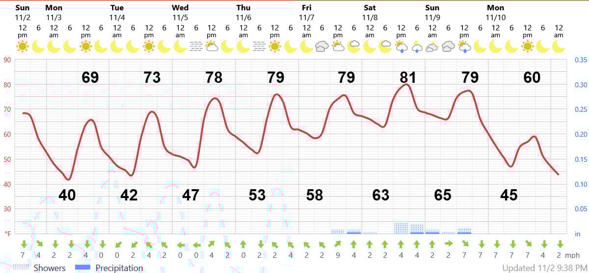
FORECAST DISCUSSION
The Foreca graphic shows the path that the coaster will follow. Tonight’s 40 at the Slidell airport could be 38 in some cold pockets near Bogalusa and closer to 50 on the Southshore. Tomorrow’s high will be a few degrees cooler than today under brilliant sunshine and Tuesday’s will be slightly warmer. The real warm-up starts on Wednesday with highs in the upper 70s.
Notice the fog symbol for both Wednesday and Thursday morning (it looks like your Iphone hamburger on the row with the sun and moon). So watch out for some scattered fog those mornings, especially in rural areas near water.
Friday will feature partly sunny skies, but more clouds will move in on Saturday with a scattered showers. Sunday will also start out cloudy with a chance of those light showers before clearing in the early afternoon. Highs all three days will be near 80.
Monday will be back to late November weather under sunny skies. Morning lows mid 40s, highs will barely reach the low 60s.
LONG-RANGE RAMBLINGS
Laying this out in tabular form…
Date LOW HIGH WX
Tuesday Nov 11 38-42 63-65 Sunny
Wed. Nov 12 45-49 68-72 Sunny
Thurs. Nov. 13 52-54 73-78 Fog (?) then Sun
Fri. Nov. 14 56-58 75-78 Sun
Sat. Nov. 15 59-63 77-79 Partly Sunny
Sun. Nov. 16 58-64 79-81 Thunderstorms
Mon. Nov. 17 Clearing and cooler….