- Wound Up on Weather
- Posts
- Several Forecast Changes
Several Forecast Changes
David Gilhousen
October 25, 2025

SUMMARY
Several forecast changes since Thursday’s letter:
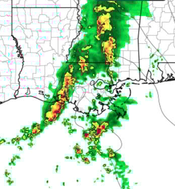
First, showers will be moving in this afternoon. Heavy thunderstorms are already in the Lafayette area, and my favorite small scale forecast model (HRRR), shown below at 4 PM) depictss them reaching our area in a weakened state. The timing: About 2 PM in Hammond, a few hours later in Slidell. The good news for the LSU game is that the rain will be ending in Baton Rouge at about 3 PM and the next line won’t arrive until after midnight

Second, the heavier line of thunderstorms will arrive in our area anytime from 5 or 6 AM Hammond to 10-11 AM Gulfport. This is the same model forecast, but for 6 AM tomorrow. The bad news is that scattered showers will probably bubble up again in the afternoon hours, making this pretty much of a wash out Sunday for anything outdoors.
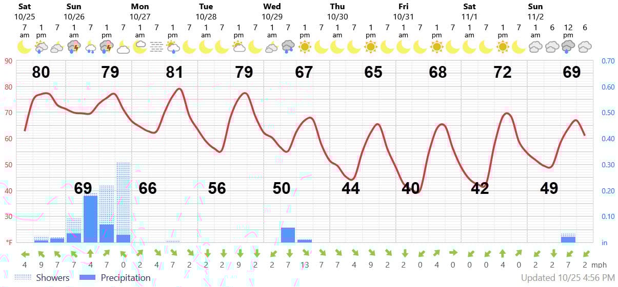
Third, the big cold front for next week is still on schedule, but temperatures will be colder than I forecast. Lows will be in the low to mid 40s Thursday and Friday on the Northshore ( low 50s Southshore) with highs in the mid- to upper-60s. See the at-a-glance graph below and discussion for more details. So….it’s time to dig out those sweaters and jackets.
AT-A-GLANCE: SLIDELL
FORECAST DISCUSSION
My biggest change from the Foreca graphic is Wednesday morning’s low of 50 rather than their 55 because I think the cold air will come in faster. Note the chance of a brief shower with the front in the pre-dawn hours of Wednesday. More significant is the wind, which I also think Foreca underplays. It could gust to 25 over land during the day on Wednesday, perhaps 35 mph over the Lake which would cause some Causeway restrictions.
Temperatures for trick or treat time Friday night will plummet from near 60 for those cute toddlers showing up at 6 PM to the upper 40s for those teens who overstay their welcome at 9 PM. Bundle up, but at least the wind will be near calm for Friday.