- Wound Up on Weather
- Posts
- Several Showers Thursday-Saturday
Several Showers Thursday-Saturday
David Gilhousen
April 29, 2025

SUMMARY
Most us will see three or four showers and thunderstorms starting — for some on Thursday, others on Friday and not ending until Saturday evening. Most rainfall will be in the afternoon and evening. When it’s all over many of us could see an inch, maybe two. That would be welcome for those of you who live in Slidell which completely missed out on last week’s rains. After that, another beautiful sunny stretch with low humidity and cooler morning temperatures from Sunday through Wednesday.
Here’s the reason why: Cold front located from Oklahoma - Illinois will move in our direction in fits and starts - very typical of late spring. Showers and thunderstorms will move out ahead of this boundary in response to daytime heating. As these impulses move east, upper level support becomes less favorable and they die only to have another round 12-24 hours later. Most models are kicking the whole thing through by Sunday.
AT-A-GLANCE: SLIDELL
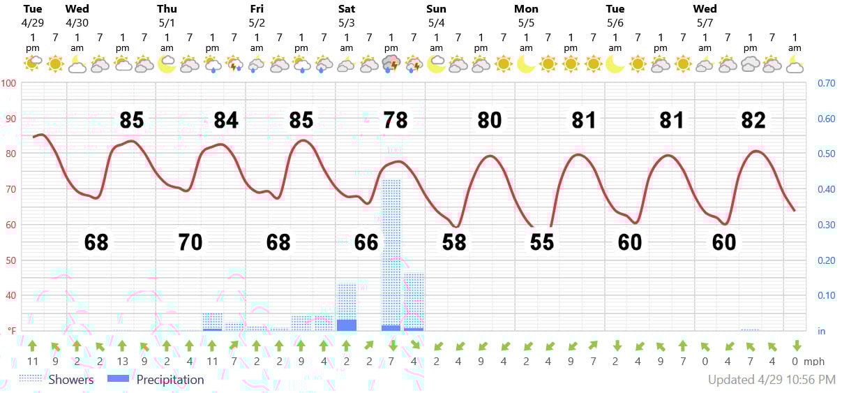
FORECAST DISCUSSION
Here’s my thoughts on the Foreca graphic:
1) More clouds than today and a degree or two cooler on Wednesday.
2) Thursday’s rains should be more of the nuisance, widely scattered, mostly Northshore variety. The only exception might be the Gulfport-Biloxi area where both the American and European models insist on putting in a band of showers coming up from the Gulf. Even there, maybe a few tenths?
3) Friday will feature scattered afternoon showers just about anywhere with a more substantial cluster of showers and maybe thunderstorms moving in from the NW in the evening.
4) Saturday will feature several rounds of showers and storms. Perhaps one in the morning hours, then a break, then another round coming from the NW in the evening hours. With extensive clouds, temperatures should be held in the upper 70s. Not a good day for much outdoors - go lose yourself in Costco like I did last Saturday.
5) Fingers crossed…system should exit by Sunday morning, giving us a partly cloudy day with sunny skies returning for Monday-Wednesday of next week. Temperatures will be cooler. Northshore lows upper 50s Sunday, maybe mid 50s Monday with low humidity. Southshore lows mid 60s, but with more wind. Highs near 80. Delightful.
LONG-RANGE RAMBLINGS
Dry cool spell will end with some showers and thunderstorms next Thursday May 8 and/or Friday May 9, then back to sunny weather with comfortable humidity for another five days. With upper air winds coming from the NW, temperatures and humidity levels will be reasonable plus low rain chances.
About that threat of something developing in the Western Caribbean or SE Gulf about a month from now….These early season developments in this area are NOT signs of an active season. I fully expect things will quiet down until August after this initial pop. I have more to share, and will post a separate outlook on the season later this week…unless the pool turns green, my meteorology students file grading complaints, or United airlines cancels my vacation flights….
ONE REQUEST: FOLLOW MY BUSINESS PAGE
If you haven’t already, follow my Facebook, “Wound Up on Weather” business page where I’ll post weather updates between the newsletter releases. Again, I don’t have a Doppler in my Dome and I don’t watch the weather 24×7, but if I see something interesting to share, that’s where I will post it.
ALABAMA & NW FLORIDA BEACHES
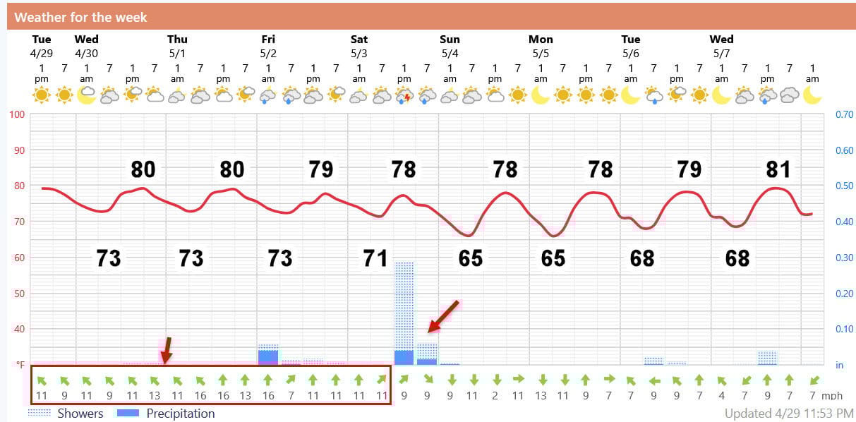
Foreca graphic for Pensacola Beach. High temperatures remain near 80, but that’s right on the beach. Get inland a few blocks and you can tack on a few degrees. Until the showers and storms arrive late Saturday, steady SE and then E winds 10-16 knots will stir up the surf. Expect red flag and possibly small craft warnings with rip currents. Afterwards, from Sunday through Wednesday, expect slightly cooler mornings with less humidity. Northerly winds on Sunday and Monday may make it feel a bit cool in the shade, they will settle the ocean front surf, but make it a bit choppy on the bays.