- Wound Up on Weather
- Posts
- Showers Thurs.-Saturday, Twice?
Showers Thurs.-Saturday, Twice?
David Gilhousen
May 01, 2025

SUMMARY
Weather settles into its patterns, and it seems like Thursday-Saturday of next week will feature some showers, too. But I’m jumping ahead of myself - what about the next couple of days?
Most of tomorrow (Friday) will actually be quite nice with showers and storms not arriving until late afternoon or evening. Saturday will feature two bouts of them, one in the early morning hours, another in the early-to-mid afternoon, but skies could clear before sunset in many places. Then, we’re in for a nice stretch of weather from Sunday - Wednesday.
And that leads me to an explanation of what I do that’s different. Modeling has improved so much, that when there’s a reasonable consensus, I tell it like the models do. If the models are showing two clusters of showers at more or less the same times, I’ll say that and provide times and locations within our area. The NWS and others, broad brush it saying there’s a 60% chance everywhere during that day. My approach obviously won’t work on many summer days when there are random small pop-up storms and there are times when I’m wrong — but on the whole, my approach provides more value.
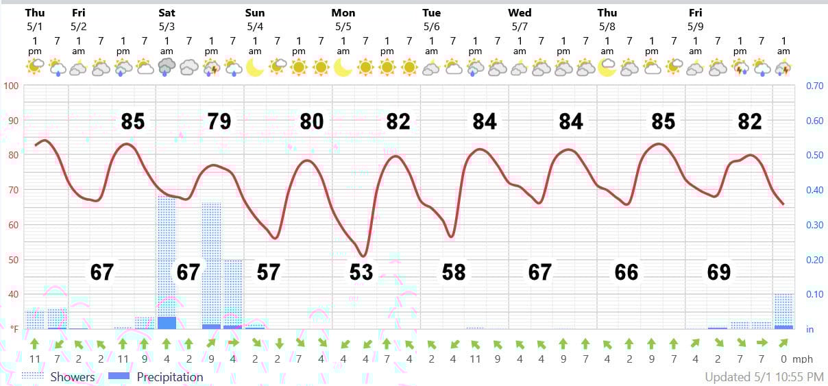
AT-A-GLANCE: SLIDELL
FORECAST DISCUSSION
Here’s some better ideas on the timing of the showers than shown in the Foreca graphic:
1) Cloudy start in many places tomorrow, breaking out into sun by mid-day. Can’t rule out a few drops on the Northshore almost anytime, but it will hardly wet the ground.
2) Main action arrives with showers and storms building mid afternoon from Washington Parish west into Northern Tangipahoa. Those storms will arrive in the Hammond-Slidell-Gulfport corridor during the 5-8 PM time and an hour later on the Southshore. Storms will last an hour or two.
3) Saturday morning will feature another round of storms from 6-9 AM and then another batch from 1-4 PM. So you could squeeze in a few chores in the late morning hours and after 4 PM without getting wet, but not a day for a round of golf.
4) Note the lower early morning temps in the 50s Sunday-Tuesday on the Northshore with lower humidity. Southshore lows will stop in mid 60s. Enjoy these stretches of lovely weather before summer sets in, and remind yourself that many places further north see this weather almost all the time during summer.
5) Next system could put showers and storms into the Baton Rouge area late Wednesday and effect us next Thursday.
LONG-RANGE RAMBLINGS
Expect several periods of showers and storms from Thursday - Saturday. It’s too early to say much. Then….another stretch of fine weather from Sunday May 11 - Wednesday May 14. Oppressive summer weather can’t be too much further away, but it’s not visible on my horizon just yet.
ALABAMA & NW FLORIDA BEACHES
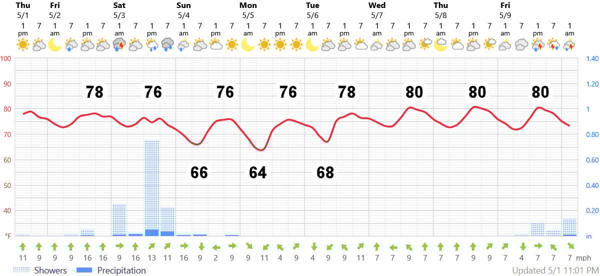
It’s about the same story in the Gulf Shores - Pensacola area. Tomorrow won’t be that bad except for the onshore wind and rough surf. Oh, you might see a pretty coastal shower or two form near daybreak before zipping inland. On Saturday: Some showers and storms expected from 9-11 AM, then again from 2-6 PM, and maybe a stray one towards midnight. After that, boy does it look nice there Tuesday-Thursday.