- Wound Up on Weather
- Posts
- Showery Week; Stormy Easter?
Showery Week; Stormy Easter?
David Gilhousen
March 29, 2026

SUMMARY
A streak of almost two weeks without rain was broken by scattered light showers moving in from the southeast this morning. Expect that pattern to continue through Wednesday with cloudy mornings, scattered, light late morning showers along the I-10/I-12 corridor (and the Southshore). The showers will move inland during the day as the cloud cover shows some breaks. So why this pattern which is more typical of summer?
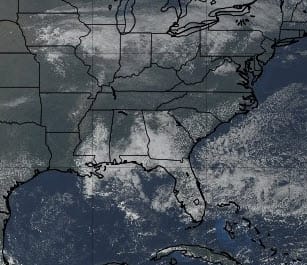
The answer is not on the surface map. Satellite imagery shows the scattered clouds and showers all along the Gulf Coast east of us reflecting low level moisture moving in from the tropics.
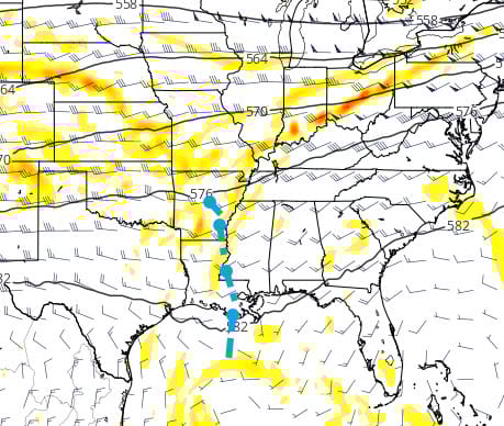
Aloft, there’s a weak trough which will give us just enough coolness to promote those puffy shower clouds to build. This is the Wednesday noon ECMWF upper air chart with the dashed line showing the trough axis. This trough will move little and actually grow stronger through the week giving us a better chance of more substantial showers and storms from Thursday and Friday. An inch or more is certainly possible.
Saturday seems like the day for less shower activity. Call it a break from the upper air feature which should move on to the east and the next big player: A dying cold front. That front arrives Easter Sunday morning but will stall in our area. There could be substantial differences in rain across the area Sunday morning. Models are currently showing the rainbands stalling from Hammond through Western St. Tammany into Pearl River County, but keeping Slidell, the Southshore, and the MS Gulf Coast mainly dry. It could be a close call on Easter morning activities. Rain chances could linger into Monday and Tuesday area wide.
AT-A-GLANCE: SLIDELL
FORECAST DISCUSSION
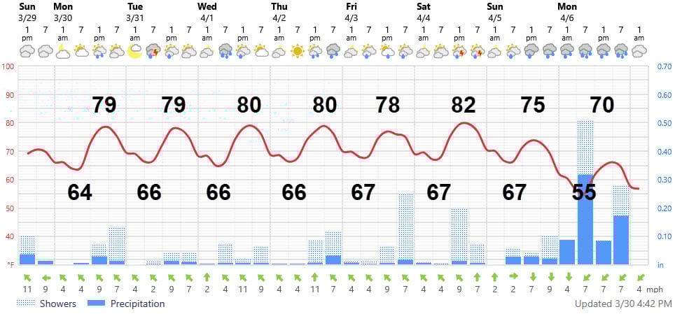
The Foreca forecast of precipitation makes it seem like it will rain everyday, but it won’t. Chances increase from 30% Monday-Wednesday to over 50% on Thursday and Friday. I actually think the rainfall amounts are underestimated for Thursday and Good Friday where we could get an inch or two. On the other hand, I think the graphic amounts are over-estimated for Saturday and especially Monday. If you live in Hammond, the Covington area, Northern St. Tammany, and Pearl River County, expect more rain than the graphic shows on Sunday. Their depiction of heavy rain on Monday is questionable. The temperature forecast looks reasonable. Fog will not be an issue because the winds will be too strong.
LONG-RANGE RAMBLINGS
Expect Tuesday April 7 to feature highs in the mid 70s and lows in the low to mid 50s. Then, a warm up begins from Wednesday through Friday of that week with highs returning to the low 80s. What’s unknown is the rainfall during this period, though models are leaning on the wet side.