- Wound Up on Weather
- Posts
- Snow unlikely Sunday morning
Snow unlikely Sunday morning
David Gilhousen
January 15, 2026
In partnership with

SUMMARY
]Everyone gets hyped here at the slightest mention of the “s” word, but honest folks, this situation is a lot different than last year’s epic event which checked all of the boxes that meteorologists look for. This ones checks none of them except “close call”. Let me explain why.
Cold air will be moving in Saturday behind yet another cold front and this map shows the European model forecast for midnight Sunday morning. Showers have broken out behind the front (the green area) which covers the Southshore and barely reaches into Southern St. Tammany Parish and the immediate MS Gulf Coast. A dashed blue line labeled “40” (really 540) cuts from the north side of Picayune to Ponchatoula, barely missing the precipitating area.
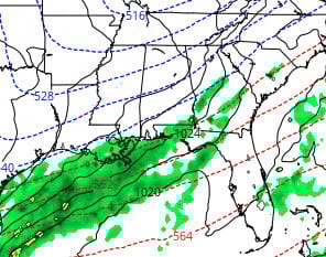
Six hours later at 6 AM Sunday, the showers have moved southeast offshore and so has the cold air. But again, nowhere is the precipitation falling in the areas where its cold enough to snow. Other factors to mention are: 1) The American GFS has backed off from its snow forecast of yesterday, and 2) Saturday’s high of 55 will make it tough for anything to stick. 3) Surface temperatures won’t flirt with freezing until daybreak, 3-4 hours after any precipitation is over so any ice on the roads looks unlikely. and 4) Precipitation amounts are piddly because the air near the ground is dry and the lifting is weak. This means less evaporative cooling to lower temperatures.

Having said all that, it will snow somewhere in the Deep South: Probably east of here in places like SE Alabama and S Georgia (the blue areas in the map above) after a low pressure area forms in the Gulf . For it to snow here, the development of the Gulf low would have to occur further west and the upper air trough with colder temperatures would have to extend further south. Not impossible, but unlikely given the speed of the jet. Even if we were to get something, an hour of snow flurries at 2 AM is not worth a trip to the bathroom.
NOTE FOR PROFESSIONAL METEOROLOGISTS: I know my discussion here is overly simplistic. I did examine the forecast soundings and 540 thickness works out as a good proxy in this situation.
One Habit You’ll Keep

By this time of the year, most New Year goals are already slipping. That’s why the habits that last are the simple ones.
AG1 Next Gen is a clinically studied daily health drink that supports gut health, helps fill common nutrient gaps, and supports steady energy.
With just one scoop mixed into cold water, AG1 replaces a multivitamin, probiotics, and more, making it one of the easiest upgrades you can make this year.
Start your mornings with AG1 and get 3 FREE AG1 Travel Packs, 3 FREE AGZ Travel Packs, and FREE Vitamin D3+K2 in your Welcome Kit with your first subscription.
AT-A-GLANCE: SLIDELL

FORECAST DISCUSSION
The Foreca graphic looks fine, except perhaps for the 26 degree reading Monday morning which looks a few degrees cold. Again, notice the themes of cold without extreme cold , the significant warm up for next weekend, and little rainfall. Frost is likely tonight, and Sunday through Tuesday mornings. There’s a lot of uncertainty concerning how much rain we’ll see towards the end of next week and whether it will fall on Thursday or Friday.
LONG-RANGE RAMBLINGS
Winter will not be over just because of the 70 degree plus reading that we will see from Thursday Jan. 22- Sat. Jan. 24. A significant cold front is coming through that Sunday and some models are forecasting lows in the 20s for Tuesday Jan. 27. Late January and early Feb. will be “Flu weather” with rapid temperature changes.