- Wound Up on Weather
- Posts
- Sunny & Pleasant First Week of 2026
Sunny & Pleasant First Week of 2026
David Gilhousen
December 31, 2025
In partnership with

SUMMARY
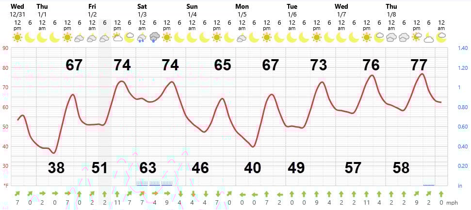
With the exception of Friday night where showers are expected, we’re in for a really nice week of winter weather. New Year’s Day will dawn sunny with lows about 10 degrees warmer than today - still in the upper 30s and low 40s. Temperatures should jump to the upper 60s by afternoon. Too bad most of us college football fanatics will be stuck indoors watching zebras throw flags.
Then, a weak low passing by from east to west well to our north ( see map below) will give us a decent chance of showers Friday evening and perhaps again near daybreak Saturday. The shower threat will end in the early morning giving us a nice Saturday before the front passes through that evening giving us cooler weather for Sunday and Monday with lows in the 40s and highs in the 60s.

Then, it’s sunny and warmer weather for the rest of the week with highs in the low 70s Tuesday and Wednesday building to the upper 70s by Thursday.
Easy setup, easy money

Making money from your content shouldn’t be complicated. With Google AdSense, it isn’t.
Automatic ad placement and optimization ensure the highest-paying, most relevant ads appear on your site. And it literally takes just seconds to set up.
That’s why WikiHow, the world’s most popular how-to site, keeps it simple with Google AdSense: “All you do is drop a little code on your website and Google AdSense immediately starts working.”
The TL;DR? You focus on creating. Google AdSense handles the rest.
Start earning the easy way with AdSense.
AT-A-GLANCE: SLIDELL
FORECAST DISCUSSION
The Foreca graphic looks perfect. Friday will have more clouds than sun but still should reach the 70s. Showers won’t be a problem until evening and amounts will be light. For what it’s worth, models seem to favor showers between 5 and 10 PM and then others developing near daybreak.
The next cold air mass won’t be nearly as bad since the high pressure area will stay far to our north. We could hit 40 in many suburban and rural areas, but maybe 43 in more developed areas. Then, it’s a warm up through Thursday courtesy of an upper air ridge, or an upward buckle in the jet stream, shown as the red an orange colors on this upper air forecast for late Tuesday.

LONG-RANGE RAMBLINGS
The upper air pattern should hold into Friday Jan. 9 giving us another warm one with lows in the 60s and highs in the upper 70s. Then, a strong trough (blue colors) builds down the Rockies to our West pushing a cold front through (Shown by the orange line on the map below) on or about Sat. Jan. 10 giving us showers. Most of the troughs this winter have been in the East, so this one is different and could give us freezing weather sometime in mid January. The strong ridge over Greenland is blocking the pattern (circled in red) and will force the cold air south (red arrow), plus there’s reinforcing cold air to the north over Alaska and the Yukon. It’s too early to say hold cold it will get or whether most of this will wind up in Texas. Markings courtesy of meteorologist Travis Roberts and graphics supplied by WeatherBell.
