- Wound Up on Weather
- Posts
- Thank you, Florida!
Thank you, Florida!
David Gilhousen
August 10, 2025
In partnership with

SUMMARY
No, I’m not a Gator fan. Not after attended Penn State and Florida State. But with the rotating shower system currently in the Southeast Gulf, you have to wonder if it would have been a tropical storm by now if it hadn’t slowly crossed Florida disrupting any formation. A meteorological friend of mine calls this phenomena “Florida Interruptus”.
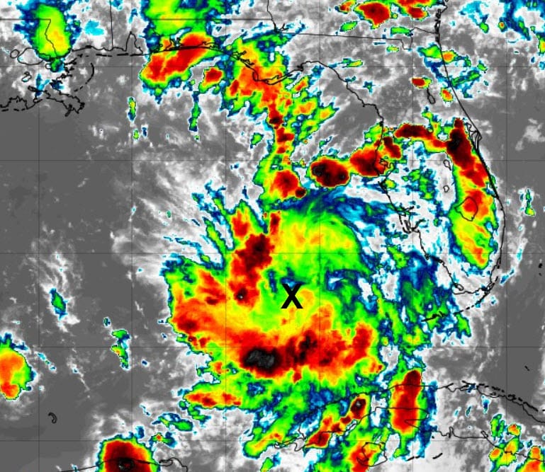
That system is currently centered a few hundred miles west of Ft. Myers, Florida (near the X) as shown in the satellite image. The problem is that there’s no thunderstorms near the center and upper level winds will rapidly become unfavorable by tomorrow. So the models aren’t developing it, nor is NHC addressing it. However, this system will be headed our way to increase showers Tuesday and Wednesday. with the heavier amounts downriver from New Orleans and in the Biloxi area.
On the other side of the Atlantic, a wave with strong thunderstorms has just come off the African continent. It’s the strongest wave we’ve seen yet, and should become a depression within a few days. As almost all storms do here, they follow the “Go West, Young Man” theme for five days, but the plot gets muddied after that — a perfect topic for “Long Range Ramblings”.

Looking for unbiased, fact-based news? Join 1440 today.
Join over 4 million Americans who start their day with 1440 – your daily digest for unbiased, fact-centric news. From politics to sports, we cover it all by analyzing over 100 sources. Our concise, 5-minute read lands in your inbox each morning at no cost. Experience news without the noise; let 1440 help you make up your own mind. Sign up now and invite your friends and family to be part of the informed.
AT-A-GLANCE: SLIDELL

FORECAST DISCUSSION
The Foreca graphic gets most of it right with the exception of tomorrow. Tomorrow should be a lot like today, with many offshore showers and storms throwing up an overcast, but a few scattered showers should creep northward and effect more of the Southshore and perhaps the Slidell - Biloxi area by late in the day. Inland areas will probably stay dry. Highs staying in the upper 80s, except inland areas that might see more sun.
More widespread showers and storms arrive with the tropical system early Tuesday. I’m not seeing a deluge, but an inch or so is certainly possible with the heavier amounts downriver and near Biloxi. With more cloud cover, expect highs in the upper 80s.
A bit above average storm coverage is still in the cards for Thursday and Friday, but with lighter amounts. Then, typical summer coverage and high temperatures in the 90s for the weekend. Next week looks hot with less rain.
LONG-RANGE RAMBLINGS
Expect the system coming off Africa to be named Erin in the next few days. It will move to a position north of the Virgin Islands and Puerto Rico by next weekend. None of the models are threatening any of the islands. It’s a this point that model forecasts scatter.

I’ve marked up the official NHC seven day outlook to indicate the right-most and left-most tracks that I’ve seen the leading models take the future Erin beyond 7 days. Some take it harmlessly out to sea, while others bring into the Carolinas and possibly New England or the Maritime Provinces. The good news is that none of the models track it near Florida or the Gulf. The Bermuda High is just too far to the east to push the storm this far west. The bad news is that Erin could become a major hurricane.
Ultimately, the track depends on three factors. First, the exact strength and location of the Bermuda High in another week to ten days. Second, the upper air pattern over the U.S. in that time period. Third, the strength of Erin in next 5-7 days will determine the exact location north of Puerto Rico. Look at that as the starting point for its next leg. We’ll probably get clues on this last one in the next few days so forecasts could consolidate a bit by mid week.
Next up in the tropics is another system that some models are developing behind Erin. Looks like I’ll have a busy August.
ALABAMA & NW FL BEACHES

Foreca graphic for Pensacola Beach shows a really cloudy and wet week through Thursday. Next weekend looks better.