- Wound Up on Weather
- Posts
- Thanksgiving Cool won't last long
Thanksgiving Cool won't last long
David Gilhousen
November 23, 2025

SUMMARY
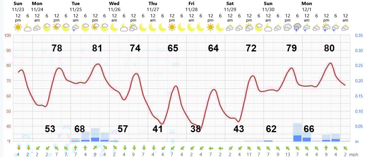
As is often the case this time of year, the cold air blows in and out quickly. This one is timed perfectly for the family and retailers: Two days of “cold” will be served up for Thanksgiving and Black Friday just to get you in that holiday mood. After that, temperatures rise as quickly as they fell.
Until then, tomorrow will be a carbon copy of today except for increasing afternoon clouds. Then, the National Weather Service mentions a marginal threat of severe thunderstorms for Monday night and early Tuesday morning, but I think anything severe will largely be confined to areas west and northwest of here such as McComb and Baton Rouge. Still, there’s a good chance that most us will see some showers and thunderstorms during the day on Tuesday. See my discussion for more info.
The cold front comes through early Wednesday, but the coldest weather won’t arrive until Thanksgiving which will a perfect one for outdoor cooking.
AT-A-GLANCE: SLIDELL
FORECAST DISCUSSION
Though there are two periods of possible rain, the Foreca graphic shows the amounts will be very light as the drought drags on. On Tuesday, we could get a few showers in the morning, mostly in Louisiana, from the left over storms that went through Baton Rouge. More likely, a few showers are possible in the afternoon for everyone. Again, it might not do much except settle the dust on cars. Here’s hoping you don’t drive a black one.
Wednesday will be partly sunny with highs about 5 degrees cooler and a nice, less humid feel to the air. Thanksgiving morning lows will be near 40 and highs in the mid 60s — about normal for a December day. Friday’s lows will be a bit cooler, 38 in rural areas with some light frost possible in the normally colder inland locations. I doubt I’ll go below 42 in my more protected part of Slidell. On the Southshore, tack on 5 degrees.
Saturday will be a gem of a day with lows in the 40s and highs near 70 with a lot of sun early and some clouds late. Sunday will be cloudy and more humid with showers developing from the next system which should last until Monday.
LONG-RANGE RAMBLINGS
Tuesday Dec. 2 should be another warm and humid one with highs in the mid 70s to near 80 and lows in the mid 60s. Another chance of showers or storms on Wed. Dec. 3 followed by a bit cooler weather. Week should end with highs in the upper 60s to low 70s and lows in the upper 40s to low 50s. No frost (other than the one mentioned for Friday in a few rural areas) or freeze in sight.