- Wound Up on Weather
- Posts
- Tropics Could Pick Up Late Next Week
Tropics Could Pick Up Late Next Week
David Gilhousen
July 29, 2025

SUMMARY
Though there’s no chance of development in the next week, an easterly wave several hundred miles off Africa has a chance of developing near the Bahamas late next week. I’ll explain the reasons why in my “Long Range Ramblings” section and give you a handful of reasons why we have no idea yet where it will end up or whether it will be significant.
Closer to home, a near solid line of storms stretching across Northern St. Tammany to Bogalusa, Poplarville, and then Gulfport is speeding to the southwest. Almost everyone on the Northshore and Southshores should get in on the action in the next three hours. The next few days should see higher shower and storm chances and slightly lower temperatures. Then, rather than go back to bone dry and bake, a very normal pattern of scattered storms look to emerge. Details follow below.
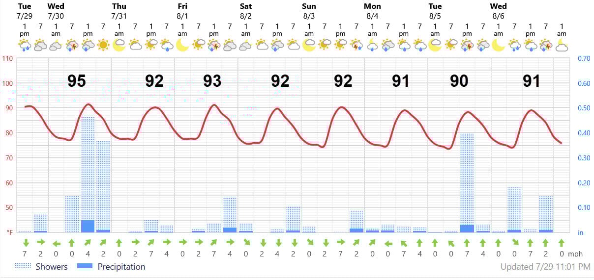
AT-A-GLANCE: SLIDELL
FORECAST DISCUSSION
The Foreca graphic shows tomorrow and Monday as the heavy rainfall days with slightly cooler temperatures and a chance of rain almost every day. Let me make more sense out of this….
After the line barrels through with gust winds this evening, expect scattered showers and storms to redevelop in the early morning hours Wednesday on the Southshore or near the Lake and Mississippi Sound. These.showers will move rapidly inland. Another round of storms should develop in the early afternoon and also head north. Given all of these, an inch or more of rain seems reasonable. Thursday will feature the same early start, but storms should really zip inland so probabilities and amounts will be lower.
Friday’s storms will take their time, so the amounts could be higher. Saturday looks to have mainly scattered afternoon and evening storms. Sunday may see very few storms and those that happen will be late. Monday looks wet.
LONG-RANGE RAMBLINGS
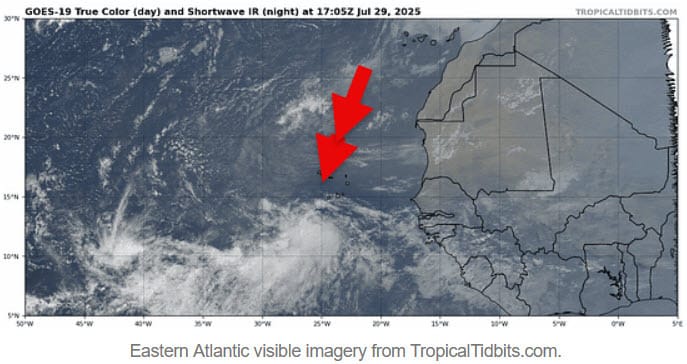
The wave that came off Africa has a bit of a spin to it (see satellite image for location ) and you might think that the National Hurricane Center (NHC) would give it at least some chance of development. However, its moving too fast to organize and conditions are not optimal. So, NHC is not even mentioning it. You might recall that I’m not expecting a lot of development this year between the islands and Africa.
However, conditions change by the end of next week. The wave slows down after it passes north of Puerto Rico and upper air conditions turn more favorable courtesy of a vigorous Madden-Julian “wave”. Hurricane Iona and Tropical Storm Keli have formed well south of Hawaii in response to this wave. So, it’s not unreasonable to think that a tropical storm could develop in the Atlantic when this wave moves through the upper atmosphere 8-11 days from now and it meets up with the surface easterly wave heading west.
Some models are showing significant development, others show a modest tropical storm, while others just push the moisture northward and out to sea. Locations vary all over the place — typical for something that hasn’t formed and is more than a week off. Uncertainty arises because we don’t know how much of this wave will be left after it traverses a somewhat hostile Atlantic, where the more vigorous showers will be located (100 miles off in a week can make a huge difference), and the exact upper air conditions over the Pacific that will influence what the winds over the U.S. will look like two weeks from now. My take is that forecasts will start pointing in the right direction in another 5-7 days.
Look at it this way: You don’t expect your MD to nail a diagnosis of some complicated ailment on the first day after the first test. Often, it takes many tests over the course of a week to reach a reasonably accurate diagnosis. We’re at the stage here where the patient is starting to feel a bit off and thinking of seeing a doctor.
ALABAMA & NW FL BEACHES
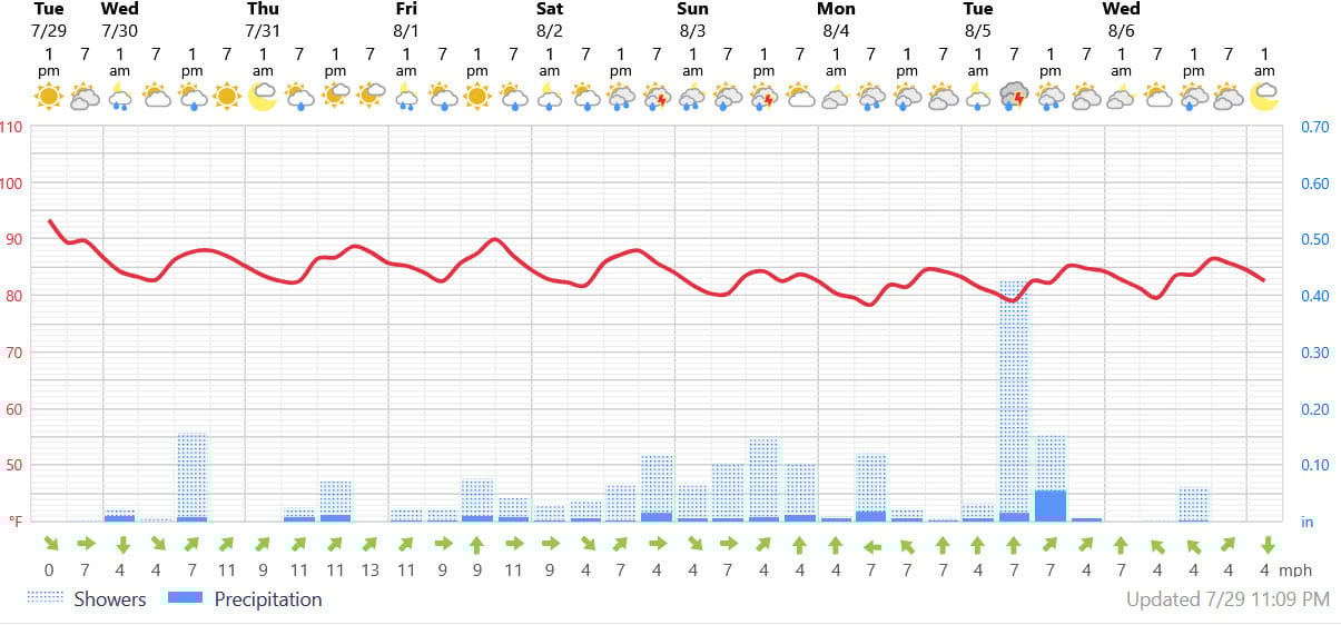
Foreca graphic for Pensacola Beach shows more sun than clouds for a few days and then it gets cloudy and wet. Temperatures drop from highs near 90 to the 80s beginning on Sunday. Not ideal beach weather after the next few days.