- Wound Up on Weather
- Posts
- Up & Down Temps, but no rain
Up & Down Temps, but no rain
David Gilhousen
December 09, 2025

SUMMARY
There’s not a lot new to say as I dash off to a Christmas party. Northwest flow aloft will drag two cold fronts through this week, but with low pressure areas (and the upper air waves that create them) passing far to our north, we’ll see no rain. Enjoy the sun.
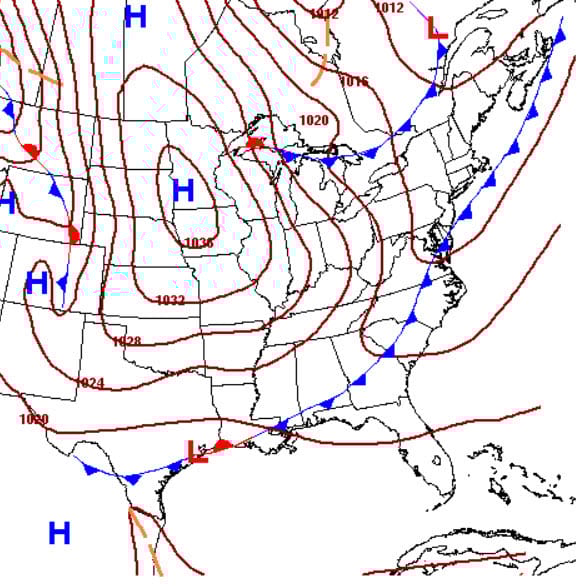
The first front comes through tomorrow evening as shown by this National Weather Service forecast map for 6 PM Wednesday. Ahead of it, enjoy a warm, sunny Wednesday. Because the high pressure behind it is weak and small (labeled “1020 H” over Oklahoma), high temperatures will dip just a few degrees for Thursday.

After that, another warm up for Friday and Saturday with highs reaching the 70s. Enjoy! The next cold front, shown on the Sunday morning forecast map, will pack more of a punch, but will only have a minor effect on Sunday. Fortunately, the larger high over Minnesota will be diving SE instead of due south. Nevertheless, Monday’s lows could be down in the mid 30s with frost possible and highs staying in the 50s.
AT-A-GLANCE: SLIDELL

FORECAST DISCUSSION
Note the complete lack of rain in the Foreca graphic and the long stretch of sunny weather except for some clouds on Tuesday and Wednesday. The only uncertainties that exist in the forecast are: 1) How cold it will get Monday and Tuesday. I’m buying the European modeling which is shown in this graphic. American models keep highs 6 degrees warmer on Tuesday. 2) The weather late Tuesday and Wednesday. American modeling brings an upper air wave over Mexico into the Gulf creating showers and storms. The European doesn’t, keeping rain out until the following weekend. With a big ridge out west, I think the European looks more realistic.
LONG-RANGE RAMBLINGS
Still no freezing weather in sight. The period from Thursday Dec. 18 - Tuesday Dec. 22 shows above normal temperatures with a showers sometime that weekend. Some long-range models are trying to bring cold air in here sometime during Christmas week, but it’s too early to say this for certain.