- Wound Up on Weather
- Posts
- Warm This Week; Cold the Next
Warm This Week; Cold the Next
David Gilhousen
January 04, 2026

SUMMARY
I’m back to my routine posting schedule after the holidays. Forecasts for the next 5-6 weeks are critical since this is when we’re most vulnerable to severe freezes. At this point, I don’t see any clear cut signs of that happening but it bears watching. Instead…
I see a warm week starting tomorrow through Friday, then a significant cold front Frinday night or early Saturday morning that will give us our next chance of a decent rain along with possible thunderstorms. After the front, slow clearing will give us a cool, clammy, cloudy Saturday, followed by fair and colder weather for Sunday and Monday. Finally, the next chance of a frost or light freeze will be Tuesday Jan. 13.
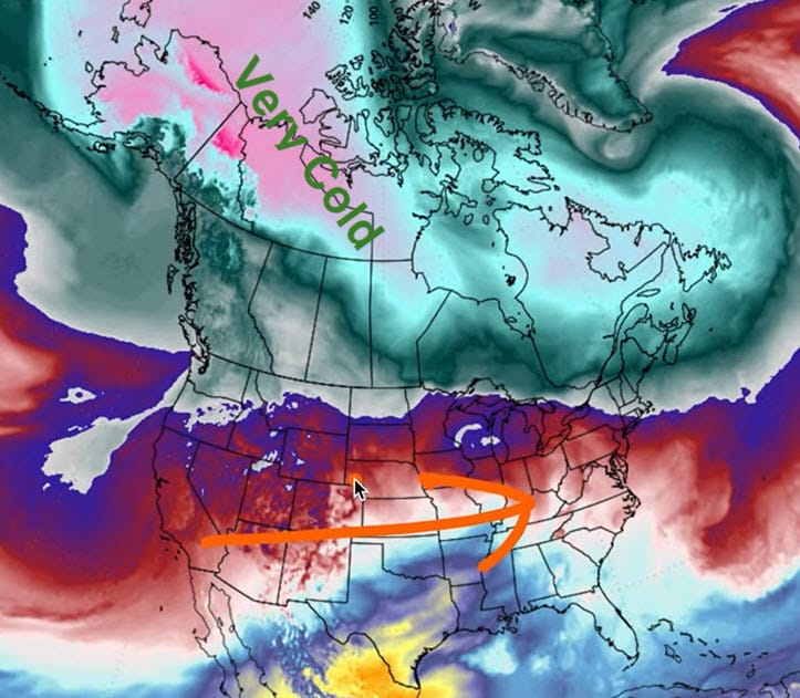
To show you why, I’ll be using a type of color contoured map that I’ve never shown before, one that shows temperatures at roughly the 6,000 foot level. The first one, valid this coming Wednesday, shows warmth in Texas (yellows) spreading our way with Arctic air bottled up in Alaska and Western Canada north of an east-west jet stream (red arrow).
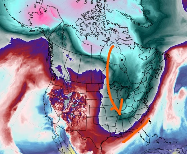
To show you why the cold air will eventually reach us, look at the same graphic for next Sunday evening. A big buckle in the jet will force the cold air south into America’s Heartland (see arrow). Though we will be in the cold air with the position of the cold front shown as a red line offshore, the bulk of that cold shot will head east of us.
AT-A-GLANCE: SLIDELL

FORECAST DISCUSSION
The Foreca graphic looks accurate. Here’s a few things to point out. First, cloudy skies will prevail until mid-day tomorrow. It’s possible there will be some patchy fog tomorrow morning in some inland areas if the cloud cover shows any breaks. Second, knock a few degrees off Thursday and Friday’s highs if you live near the Lake in St. Tammany or Sound in MS because of a nice breeze coming off cold water. Third, note the mix of clouds and sun through most days this week. There won’t be that brilliant all-day sun.
Fourth, note the drawn out nature of the showers late Thursday - early Saturday. Thursday’s showers, if any, will be very light and in the evening hours. More serious showers and storms won’t start until late Friday afternoon and there could be a few rounds of them before they end before daybreak on Saturday. Though it always seems like models overestimate the rain five days ahead of time, I could see us getting an inch or two from thunderstorms because this will be a slow moving affair.
Finally, note the gradual cool down with the coolest air not arriving until Monday to Tuesday morning where I can see a frost or light freeze with Northshore temperatures ranging from 27-34.
LONG-RANGE RAMBLINGS
After next Tuesday’s light freeze, next Tuesday Dec. 13’s highs should reach the upper 50s to near 60. Next Wednesday the 14th will be a bit warmer with lows in the low to mid 40s and highs in the low to mid 60s. However, extended range models show another big dip in the jet for next Thursday (see below) giving us another chance of freezing weather on the 15th or 16th. It’s too early to say how significant this second part of the double wammy will be. Some modeling is pointing the dip more towards Louisiana and Texas which would mean a more significant freeze - but it’s just too early to say.

After that, expect warmer weather to prevail for the last two weeks of January. I’m still expecting another light freeze or frost event in February.