- Wound Up on Weather
- Posts
- Warm week; cold returns late Sunday
Warm week; cold returns late Sunday
David Gilhousen
December 21, 2025

SUMMARY
On the radar, a broken line of showers extends from near Perkinston, MS to Picayune to Bush to Folsom and Hammond with showers ahead of a weak cold front. The showers are moving ESE and will probably reach the Slidell-Gulfport area during the evening. Also, there’s a few separate showers on the Southshore. Amounts should be light, generally a few tenths.
That front is shown on the surface map for this evening just north of us. Ahead of it are the showers, notice the darker green representing a slightly better chance in areas just NW of most of us (Bogalusa-Hammond) where it’s presently raining. That front will push through by morning.

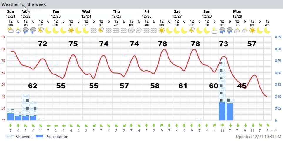
The “ cooler” air will only amount to five degrees, so Monday’s highs should still reach the low 70s instead of today’s, almost-too-warm 79! Then, with the jet stream far north and high pressure in our area, we’ll warm to the mid-70s through Christmas, upper-70s after that. Again, the big concern and one of the trickiest elements to forecast would be morning fog.
The next cold front and chance of showers will be next Sunday. It will usher in a more substantial drop in temperatures with highs near 50 on Monday Dec. 29 and Tuesday morning lows in the 30s. .
AT-A-GLANCE: SLIDELL
FORECAST DISCUSSION
The Foreca graphic looks perfect. Showers could linger or reform later tonight before ending or moving north near sunrise. Tomorrow’s highs will be a bit cooler as will Tuesday morning’s low. In between showers, the NWS indicates a chance of fog tonight and I can’t disagree. The Foreca graphic may not show it because the shower symbol takes precedence. Sun should break out by afternoon.
Tuesday looks just about perfect with lows of 55 and highs in the mid 70s under bright sunshine. Then, note the foggy mornings predicted by Foreca fpr Wednesday, Thursday, and Friday. The more likely locations would be near the Lake and Mississippi Sound.
The warm Christmas stretch ends with a chance of showers next Sunday ad the a rapid drop in temperatures with a strong north wind behind the front. Next Tuesday morning’s lows will be in the 30s.
LONG-RANGE RAMBLINGS
Expect 2-3 days of cooler weather to end the year, followed a warm up back to near 70 by New Year’s Day. That follows the theme of this winter: Brief cold spells where the bulk of the cold weather heads east and we just get sideswiped by it. Here’s my forecast for the following week:
Tuesday Dec. 30, Low 35 High 57 Sunny
Wednesday Dec. 31 Low 64 High 64 Sunny
Thursday Jan 1 Low 53 High 70 Sunny
Friday Jan 2 Low 52 High 72 Sunny
Saturday Jan 3 Low 55 High 75 Showers