- Wound Up on Weather
- Posts
- Week of Cold without deep freeze
Week of Cold without deep freeze
David Gilhousen
January 08, 2026

SUMMARY
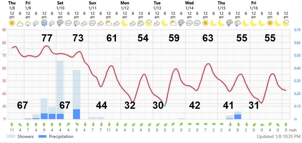
After Friday and Saturday’s showers and storms, we’re in for about eight days of below normal weather with frosts and light freezes, but not the pipe-busting, tropical plant-killing hard freeze. Translation: Highs mostly 50s and a few low 60s, lows a few upper 20s, mostly 30s and a few low 40s.
But first, let’s talk about this slow moving system moving in. A few showers should break out in the pre-dawn hours tomorrow with the bulk of the showers and storms between noon Friday and 10 AM Saturday. The Weather Service has statements out about severe weather and a flash flood watch, both of which are stretching it.
Yes, a few spots could see 2-4” of rain, but with the rain spread out into several storms over a 12 hour period and the ground fairly dry, I have a hard time seeing more than temporary street flooding. 1-2” sees more likely with the immediate Gulf Coast (Gulfport/Biloxi) getting even less. Strong thunderstorm winds and tornadoes, if they occur, will probably be limited to areas north and west of where I live such as Kentwood, Franklinton, and Poplarville Friday afternoon or evening.
AT-A-GLANCE: SLIDELL
FORECAST DISCUSSION
Few changes with the Foreca graphic until late next week. The prolonged period of showers in the graphic should not be interpreted as a steady, all day rain. Rather, it reflects the uncertainty of when we’ll get showers Friday afternoon and evening. Odds are that most of us will see 2-3 periods of showers and storms.
Monday, Tuesday, and now Friday morning are where frosts and/or light freezes should occur. Like other systems this year, the bulk of the cold air in the Midwest has moved east rather than south and I expect this trend to continue. Tuesday morning’s 30 could mean 28 in a few normally colder, rural locations. Southshore lows should remain near 40.s
There will be more cloudiness than most of us like with cloudy skies from tomorrow through Sunday morning. We’ll probably see some high clouds Tuesday afternoon through Wednesday morning. Then another batch Thursday morning with some light, cold showers that will signal the arrival of another reinforcing batch of cold air.
LONG-RANGE RAMBLINGS
The cold will not be over next Friday. Saturday Jan 17 should feature increasing cloudiness with a cold rain breaking out with lows in the 30s and highs in the 50s. It’s possible that some areas just north of us such as McComb or Hattiesburg could see some sleet - but it’s way to early to say much more than we’ll be looking at it. Sunday Jan. 18 should see clearing and cold weather with lows near 30 and highs low 50s. Then, a a few days of fair, seasonable weather with highs near 60 and lows near 40 followed by a big warming trend from January 21 to month’s end.