- Wound Up on Weather
- Posts
- Weekend Colder than Yesterday
Weekend Colder than Yesterday
David Gilhousen
January 27, 2026

SUMMARY
Yes! Saturday’s high will stay in the 30s and it could be a degree or two colder Sunday morning than this morning’s 19.9 degrees (a non-significant digit if I ever saw one). Also, the wind will gust to almost 30 mph Friday night yielding wind chills 15 degrees cooler than the actual temperatures. With tonight’s temperatures in 25-32 range on the Northshore, and tomorrow night’s near freezing temperatures, keep everything outside tightly wrapped until a week from now. Mardi Gras parades Friday night and Saturday look quite doubtful.
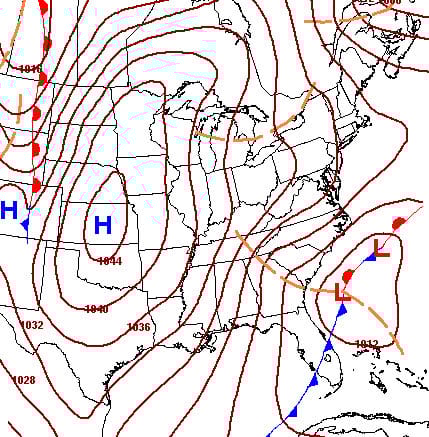
There only good news for this week is that afternoon highs have recovered into the 50s and temperatures will stay above freezing from Thursday morning until late Friday at the earliest. Weak SW return flow off the Gulf will ahead of a low pressure area on Friday will cause the warm up (See Friday morning’s forecast map below). Though there’s a slight chance of a stray shower early Friday morning with the low, it won’t amount to anything and will be gone well before temperatures plunge.

As the low moves to the northeast off the Carolina coast by Saturday morning, cold air has rushed south becoming well entrenched in our area. The only really good news is in the long-range. Temperatures will stay above freezing from next Wednesday through mid-February in a dry pattern.
AT-A-GLANCE: SLIDELL

FORECAST DISCUSSION
The Foreca graphic comes in a little colder than the model consensus from Saturday on. So, my numbers are a few degrees higher here. Even still, as the song goes, “Baby, it’s cold outside.” Here’s a few forecast pointers:
1) Tomorrow morning will be frosty just about everywhere except the New Orleans CBD. Thursday morning, less so on the Southshore, but still most places on the Northshore. Expect 5-6 degree variations within the Northshore.
2) Friday evening’s temperatures will plummet quickly through the 40s. The big problem for the parades will be the north wind 10-15 with gusts to 30.
3) Saturdays afternoon highs will stay in the mid- to upper 30s. Morning will chill temperatures should be at or below 10 degrees. Winds can still gust into the 25 mph range, so with mid-day wind chills in the 20s, I again think its too cold for parading.
4) After Sunday morning’s teens and low 20s (for a few of us in well developed suburbia), the trend is all up. However, Monday morning will still be below freezing everywhere on the Northshore.
LONG-RANGE RAMBLINGS
Next chance for showers next Thursday or Friday, Feb. 5 or 6.
Thursday Feb. 5 Low 47 High 64
Friday Feb. 6 Low 42 High 62
Saturday Feb. 7 Low 38 High 58
Expect seasonable temperatures through mid-Feb. with most highs in the 60s, most lows 40-45. Don’t see a freeze in this period. So after this weekend, it looks OK to fertilize trees and lay down per-emergent weed prev-enter. Precipitation should be below normal with a dry NW flow aloft, but with the cold retreating northward.