- Wound Up on Weather
- Posts
- Wet Sunday Morn.; Cool Halloween
Wet Sunday Morn.; Cool Halloween
David Gilhousen
October 23, 2025

SUMMARY
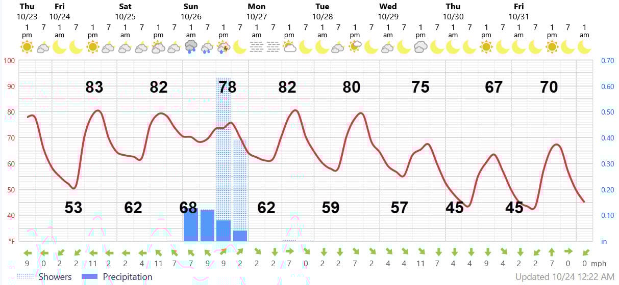
After a beautiful Friday and Saturday, several rounds of showers and thunderstorms will move through Sunday morning courtesy of an upper air feature. This should be our best chance of that 1-2” rainfall that we need. Timing will vary, especially if you are heading to the Southshore or Baton Rouge areas, so read the details in the Forecast Summary section.
A cold front is not associated with the rain, but that front will move through sometime on Tuesday, filtering in the cooler air. The real impact will arrive on Wednesday and next Thursday with a real fall feel to the air. Effects will linger through next Saturday. Next Thursday will be the coldest day with highs stuck in the 60s and lows in the 40s with wind.
AT-A-GLANCE: SLIDELL
FORECAST DISCUSSION
The Foreca graphic looks good except for some minor tweaks in temperature. Also, I need to explain those rainfall bars. A bar indicating rain at 7 PM does not mean that it will be raining at 7 PM. It shos the rainfall amount expected in the 6-hour period ending at 7 PM, which could occur at 1:15 PM. That’s what I expect on Sunday, that the rain will be over in the early afternoon. I’m getting ahead of myself, so let’s back up to tomorrow, Friday.
Friday: Just another beautiful sunny day with lows ranging from the low 50s in rural Northshore locationss to the upper 50s in some of the more densely populated areas — 60s for lows on the Southshore. Highs 82-85 with the higher values in locations well inland.
Saturday depends on where you live: For most of us on the North (and South) shore, a sunny start with increasing clouds in the afternoon. 20% chance of late afternoon and evening showers in Western St. Tammany, Tangipahoa and Washington Parishes plus the River Parishes. Humidity will be noticeably higher.
If you are in the Baton Rouge area, expect a good chance of showers and thunderstorms anytime from mid-day through the afternoon. Then, a miracle happens. LSU wins?!? Maybe yes, maybe no, but models are showing that that the afternoon showers and storms move south leaving a break in the action before others arrive around midnight. That might be enough to get the game in without delays.
Sunday is when the main event occurs for most of us with several lines or batches of showers and storms moving from W to E anytime from shortly after midnight in the Hammond area to when it ends around 1 or 2 PM in Gulfport/Biloxi (maybe 3 PM on the Southshore). It won’t be raining during that entire time, but many of us will experience 2 or 3 downpours during a 4- or 5- hour period. Sun may poke through in the afternoon shortly after the rain ends.
Monday will be surprisingly warm and somewhat humid with lows low-mid 60s, highs low 80s and mostly sunny skies. Tuesday the front arrives, but it should come through dry except for a few clouds. Highs will still be around 80. but you’ll feel a chance by late in the day.
Wednesday will feel like you took a flight to Chicago, say in September. Sunny, breezy with gusts to 20 mph over land, 25 mph over the water. Lows mid 50s Northshore, Highs low-mid 70s.
Thursday, our coldest day, will start out with lows in the mid 40s (Southshore mid-upper 50s), highs upper 60s. Still windy, especially near the water.
Friday: Sunny. Lows the same as Thursday. Wind dies down. Highs about 70. Temperature for trick-or-treat time near 60 falling into the 50s. Nice!
LONG-RANGE RAMBLINGS
Before we get to the tropics….expect a beautiful dry half-week from Saturday Nov. 1- Wednesday Nov. 5 with temperatures recovering to their typical, slightly above normal state. Highs by Tuesday, upper 70s, lows low 60s. My take is that the above normal spell will continue through the end of the first week, then drop to below normal readings — but I’m not 100 percent certain here.
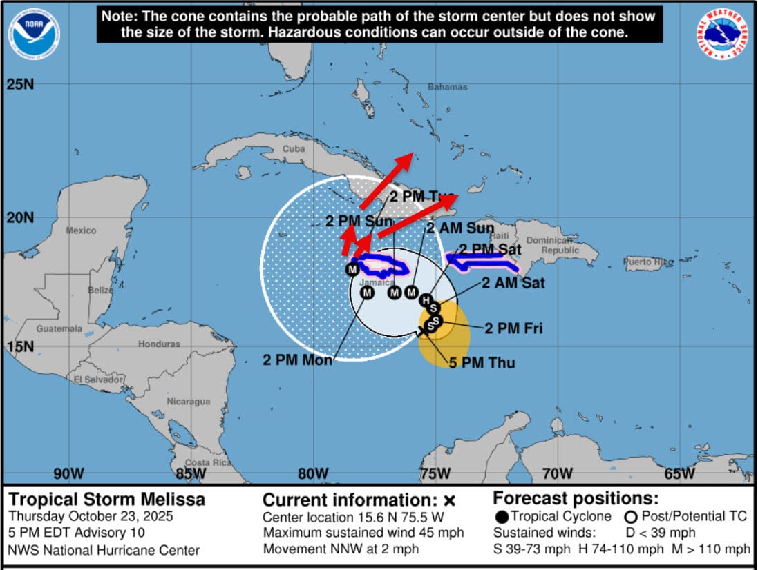
In the tropics, Melissa is still a highly sheared, very slowly moving tropical storm in the middle of the Caribbean. However, upper level westerly winds creating that shear are expected to lift northward thus greatly reducing the shear. Then…Vavoom! With warm waters and a moist environment, Melissa should quickly become a hurricane, and probably even a major one.
The Euopran AI model (actually developed by Google and called “Deep Mind”) has snapped back eastward to join the ECMWF forecast, which the National Hurricane Center now agrees with. See the forecast below. This slowly curves Melissa south of Jamaica before taking it over or near the west end of the island. Beyond this, Melissa should move over Eastern Cuba and parts of the SE Bahamas. My red arrows show two possible paths. Neither are near Florida. Jamaica and Eastern Cuba will probably receive catastrophic damage.