- Wound Up on Weather
- Posts
- Wet Weather for Late May
Wet Weather for Late May
David Gilhousen
May 17, 2026

SUMMARY
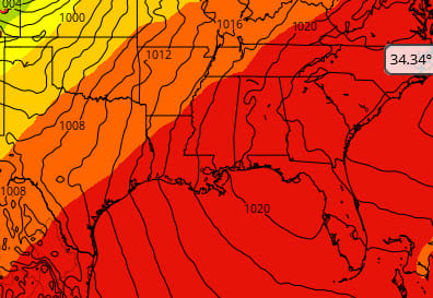
Remember those frogs? They didn’t disappear; they just went into hiding. A wet weather pattern will arrive late week, but pesky pop-up showers will dominate through Wednesday, just like today. This map shows the ECMWF forecast for tomorrow mid-day with black contours showing a potent flow of Caribbean and Gulf moisture at the surface. By mid-day, surface heating bubbles up showers in the unstable atmosphere. At higher altitudes, we’re still under a strong ridge donated by the red colored area. This means the showers are capped and shallow, so they stay small and don’t turn into thunderstorms.
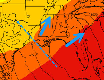
But later this week, the upper air pattern changes with the ridge breaking down (red retreats to Florida). Friday night a short wave trough crosses Louisiana (blue dashed line below) with winds that diverge or spread apart (blue arrows) ahead of it. This will create more powerful updrafts meaning Kaboom: More widespread and heavier thunderstorms for the Memorial Day Weekend. Read on as I try to be more specific concerning the rainfall pattern in the next week.
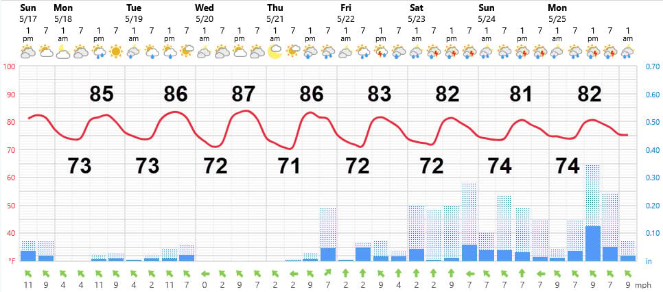
AT-A-GLANCE: SLIDELL
FORECAST DISCUSSION
The Foreca graphic captures the essence of this transition back to the frog pond. Tomorrow and Tuesday will be like today, except rain chances might be a bit lower, say 20%, except for Gulfport-Biloxi where they will be almost zero. Showers will be short-lived and light in the mid-day and afternoon hours. A nice sea breeze will keep it reasonably pleasant.
Wednesday’s hole in precipitation is deceitful. The River Parishes, Tangipahoa, Western St. Tammany, and Washington Parishes will certainly see them, but the chances of them in other areas is low.
Thursday will be a different story for most. Preciptation will be active with larger showers and some thunderstorms that could occur almost anytime. The only area that could miss out: Gulfport-Biloxi.
Friday will feature widespread showers and thunderstorms across the entire region with the heavier totals stretching from the River Parishes through Tangipahoa, Western St. Tammany, into Washington Parish and Pearl River County. It’s a few days out, but at this point it looks like totals could add up into the multiple inch range.
Saturday through Monday just look wet with more of that heavier precipitation finally getting into the Slidell and MS Gulf Coast region. If you are planning a big event outdoors, I’d have an alternative plan. I wouldn’t be surprised to hear flash flood watches and warnings.
LONG-RANGE RAMBLINGS
Geesh…the long-range just looks awful with a good chance of showers and storms each day from this Friday through about June 2 or 3. Temperatures will stay reasonable for lat May…..low 80s for highs. Traveling to an Alabama or NW Florida beach won’t yield much better weather. After that, models are forecasting much more sun, much less precipitation, and summer heat to build in.
ALABAMA & NW FL BEACHES
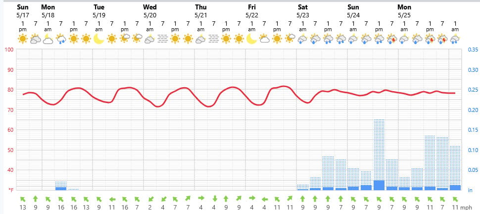
Foreca graphic for Pensacola Beach shows a windy affair for a few days, then really nice beach weather Wednesday through Friday followed by the same crappy weather we’re expecting for next weekend. If you head closer to Panama City, you might be able to salvage next Saturday.