- Wound Up on Weather
- Posts
- Winter Weather Outlook
Winter Weather Outlook
David Gilhousen
October 30, 2025
In partnership with

SUMMARY
We’re in for some really beautiful, but dry fall weather for the next few weeks. Though temperatures will moderate, there will be little return flow from the Gulf with increasing humidity. That’s because of a persistent NW flow aloft and high pressure across the South.
So, without a lot to talk about in the next week, it’s time to share my guru’s thinking about this winter. I seek help here because the monthly and seasonal forecast methods used were developed well after my college career and are quite a bit different from the models I use to make 2-10 day forecast.
Looking for unbiased, fact-based news? Join 1440 today.
Join over 4 million Americans who start their day with 1440 – your daily digest for unbiased, fact-centric news. From politics to sports, we cover it all by analyzing over 100 sources. Our concise, 5-minute read lands in your inbox each morning at no cost. Experience news without the noise; let 1440 help you make up your own mind. Sign up now and invite your friends and family to be part of the informed.
AT-A-GLANCE: SLIDELL
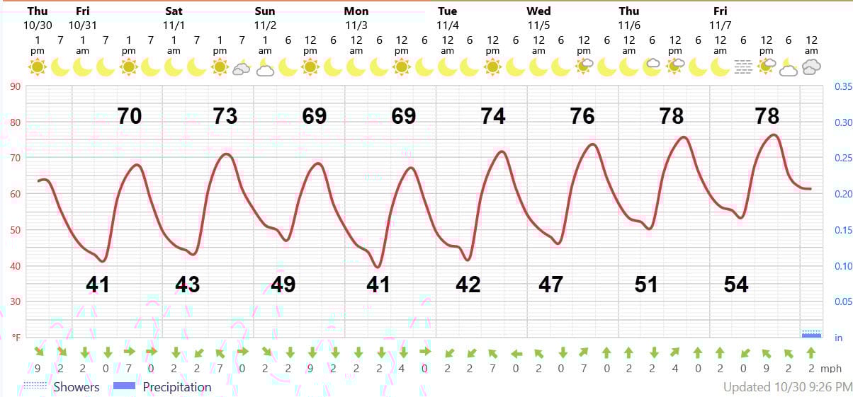
FORECAST DISCUSSION
The Foreca graphic shows the beautiful boredom. Tonight and Halloween will be perfect for costume wearing with its fair and cool weather with light winds. There will be a lot of temperature differences with the Northshore and South Mississippi the next two evenings. Rural areas will see 40-43 degrees while the more developed areas could stop in the mid- to-upper 40s. Southshore lows will stay near 50.
Saturday afternoon will be a tad warmer, but clouds will move in due to a weak front coming in from the northwest. We could see a few sprinkles late Saturday night but it won’t amount to anything. That hour or so of light rain is a bit more likely on the Southshore, but might even miss New Orleans by staying to the south. Skies will rapidly clear Sunday morning.
Sunday and Monday will be a little cooler with highs struggling to reach 70 and lows somewhere in the 40s depending on where you live. Then, a warm up will occur from Tuesday to Friday of next week with highs reaching the upper 70s, but lows still in the 50s. Note the complete lack of rain.
LONG-RANGE RAMBLINGS
The next chance of rain appears to be a week from Saturday, Nov. 8, but these should be light showers and it doesn’t look like it will be an all-day washout. That Saturday’s highs should be in the upper 70s and lows in the upper 50s. Sunday Nov. 9 and Monday Nov. 10 should be sunny with highs low 70s, lows low-mid 50s. Fair weather with highs in 70s, lows in upper 40s to mid 50s should continue through that Wednesday with the next shower system moving in anywhere from the 13th to the 15th.
Mid-November appears mild, slightly above average. For what it’s worth, Accuweather is forecasting the next significant drop in temperatures to happen around Nov. 23-25.
NOW FOR THE WINTER OUTLOOK
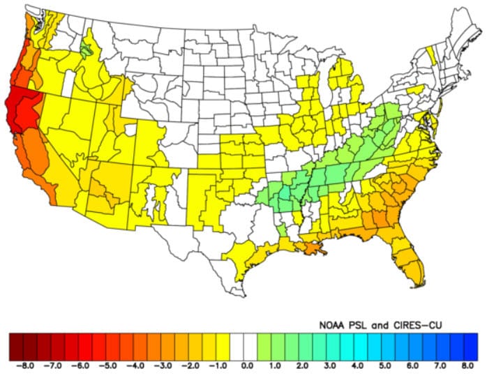
Temperatures should average about normal with precipitation below normal (see maps below). Because the outlook calls for the jet stream to travel north of here, I expect very few Gulf Coast storms. This explains why there will be less rain than normal and also why cold air will have a harder time making it this far south. However, that does not mean that we won’t see a cold air outbreak featuring freezing temperatures as I explain below.
The Northern Plains will see temperatures well below average with below average (courtesy of that jet stream dip) temperatures stretching from Texas and NW Louisiana into Tennessee and the Mid-Atlantic region. With precipitation above normal from Arkansas into Tennessee into Western Pennsylvania, these areas could see snow this winter.
Also…because the cold air with possible January snow cover could be relatively close to us in the Central US, odds are good that we will see some freezing weather on at least one occasion. My guru thinks that Texas will see the worst of it, so perhaps we’ll get more of a moderate freeze event - but that’s speculative at this point.
Also, I doubt we will see another snow event like last year. To my knowledge, there’s never been two years in a row where our area has seen snow. And when it happens, you almost always need a deepening Gulf Coast low near us - something we will probably not see this year.
By the way, my guru, Joe Bastardi, created these by matching present sea surface temperature and stratospheric wind patterns to those recorded in history. He then took several of the years featuring the best matches and averaged the resulting temperature anomalies coming up with this.
A more physical explanation: A warmer than normal Pacific will lead to a ridge (bump northward) in the jet stream which will induce a downstream trough (Dip southward) over the Central US), But because the Pacific warmth extends so far north, the predominate jet stream will stay north of the Southern US.

Temperature Outlook for this winter. Greens and blues are below normal.
Precipitation Outlook this winter (Green is above normal)
ALABAMA & NW FL BEACHES

Foreca graphic for Pensacola Beach shows a really nice Memorial Day weekend with highs low 80s, and only a slim shower chance Monday afternoon. South wind ahead of this next system on Monday may bring in some rough surf, but shouldn’t be a problem until then.